|
search place name
|
||
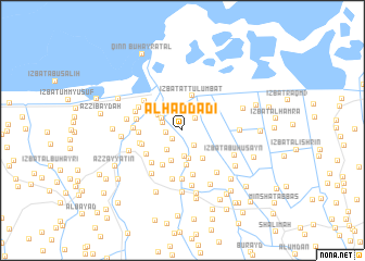
Al Ḩaddādī (Kafr ash Shaykh, Egypt)Al Ḩaddādī is a town in the Kafr ash Shaykh region of Egypt. An overview map of the region around Al Ḩaddādī is displayed below.
regional and 3d topo map of Al Ḩaddādī, Egypt ::
Al Ḩaddādī airports ::
The nearest airport is ALY - Alexandria Intl, located 81.4 km west of Al Ḩaddādī.
Other airports nearby include PSD - Port Said (138.4 km east), CAI - Cairo Intl (146.4 km south east), Nearby towns ::
‘Izbat Abū Khalīfah (1.2km south west) //
‘Izbat Ibrāhīm al Ballāşī (1.5km west) //
Dimrū (1.7km north east) //
Al Ballāşī (1.8km south east) //
‘Izbat ash Sharāqwah al Qiblīyah (1.9km north west) //
‘Izbat Jād Allāh (2.2km north west) //
‘Izbat Abū ‘Īsá (2.4km south west) //
‘Izbat Aḩmad al Ballāşī (2.7km south) //
‘Izbat Shihāb (2.7km north west) //
‘Izbat ‘Abd Allāh Abū Misā‘id (3.0km south) //
‘Izbat al ‘Atīqī (3.3km south) //
‘Izbat Abū Ḩusayn (3.5km south) //
‘Izbat aş Şayyādīn (3.3km north west) //
‘Izbat Shams ad Dīn (3.4km south east) //
‘Izbat aţ Ţulumbāt (3.6km north) //
‘Izbat Şalāḩ (3.9km south west) //
‘Izbat Aḩmad ‘Abd ad Dāyim (3.8km west) //
Az Zuhayrī wa al ‘Aw (3.8km west) //
‘Izbat Sa‘d Aḩmad (4.0km south west) //
‘Izbat Abū ‘Awf (4.2km south west) //
Al ‘Uqlah al Baḩrīyah (4.0km west) //
‘Izbat al Wizz (4.6km south) //
‘Izbat Jalūh (4.2km west) //
‘Izbat al Jawābir (4.4km north west) //
‘Izbat al Bakārwah ash Sharqīyah (5.0km south) //
Az Zayyātīn (4.3km west) //
Al Ḩamāyidah (4.5km north west) //
‘Izbat al Bakārwah al Gharbīyah (5.1km south) //
Al ‘Azīzah (4.6km north west) //
[all distances 'as the bird flies' and approximate]  Places with similar names to Al Ḩaddādī, Egypt ::
// Al Ḩudayd (IQ)
// Al Ḩaddād (EG)
// Al Ḩudūd (EG)
// Al Ḩaddādah (TN)
// Al Hedet (TD)
// Al Ḩaddādah (SA)
// Al Ḩudayd (SD)
// Al Ḩaddādah (JO)
// Al Ḩidādah (SY)
// Al Ḩadāʼidah (EG)
Disclaimer :: Information on this page comes without warranty of any kind |
||
|
Where is Al Ḩaddādī? Elevation and coordinates ::
Latitude (lat): 31°19'46"N Longitude (lon): 30°47'13"E
Elevation (approx.): 2m (map arrows pan, magnifying glasses zoom) |
||
|
Visiting Al Ḩaddādī? Hotel/Accommodation ::
Book a hotel in Al Ḩaddādī Travel Guide ::
Buy a travel guide for Egypt rental cars ::
car rental offers GPS waypoint ::
download a GPX waypoint (PoI) of Al Ḩaddādī for your GPS receiver
|
||