|
search place name
|
||
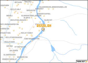
As Salām (Al Baḩr al Aḩmar, Egypt)As Salām is a town in the Al Baḩr al Aḩmar region of Egypt. An overview map of the region around As Salām is displayed below.
regional and 3d topo map of As Salām, Egypt ::
As Salām airports ::
The nearest airport is CAI - Cairo Intl, located 195.1 km north of As Salām.
Nearby towns ::
Abū ‘Azīz (1.8km west) //
‘Izbat ash Shaykh Ḩasan (2.6km south west) //
Nazlat ‘Amr (2.6km north west) //
Al Fārūqīyah (2.6km north west) //
Kafr ash Shaykh Ibrāhīm (4.3km north) //
Al ‘Aşīyāt (4.3km north) //
Kufūr aş Şūlīyah (4.4km north west) //
Nazlat Abū Shiḩātah (4.9km west) //
Nazlat Abū Ḩusaybah (5.0km west) //
Aş Şawāʼiţah (6.0km south west) //
‘Izbat as Sawāyţah (6.0km south west) //
Ash Shaykh Faḑl (6.6km north) //
Nazlat ad Dalīl (6.4km north west) //
Nazlat Thābit (6.6km west) //
Al Manshīyah al Jadīdah (7.6km north west) //
Al Qays (8.1km north west) //
Banī Sāmiţ (8.9km north) //
Banī Mazār (9.5km north west) //
[all distances 'as the bird flies' and approximate]  Places with similar names to As Salām, Egypt ::
Disclaimer :: Information on this page comes without warranty of any kind |
||
|
Where is As Salām? Elevation and coordinates ::
Latitude (lat): 28°25'50"N Longitude (lon): 30°50'55"E
Elevation (approx.): 39m (map arrows pan, magnifying glasses zoom) |
||
|
Visiting As Salām? Hotel/Accommodation ::
Book a hotel in As Salām Travel Guide ::
Buy a travel guide for Egypt rental cars ::
car rental offers GPS waypoint ::
download a GPX waypoint (PoI) of As Salām for your GPS receiver
|
||