|
search place name
|
||
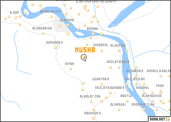
Mūshā (Asyūţ, Egypt)Mūshā is a town in the Asyūţ region of Egypt. An overview map of the region around Mūshā is displayed below.
regional and 3d topo map of Mūshā, Egypt ::
Mūshā airports ::
The nearest airport is LXR - Luxor Intl, located 217.0 km south east of Mūshā.
Nearby towns ::
Shuţb (3.6km north) //
Rīfah (3.4km south west) //
Qirqāriş (3.9km north east) //
An Nazlah (4.8km south) //
Awlād Ibrāhīm (5.2km north) //
Bāqūr (5.0km east) //
Duwaynah (6.0km south east) //
Bişrah (6.2km north) //
Az Zāwiyah (6.4km south) //
Ash Shaghabah (6.8km north east) //
Nazlat ‘Abd Allāh (6.9km north west) //
Durunkah (6.6km north west) //
Al Wāsţá (7.2km north) //
Nazlat Bāqūr (6.6km east) //
Al Muţī‘ah (6.9km east) //
Nazlat Manshīyat al Ma‘şarah (7.9km north) //
Nazlat at Tall (7.9km north) //
Awlād Sirāj (7.9km north) //
Nazlat al Kallābāt al Gharbīyah (8.7km north) //
Nazlat al Kallābāt al Gharbīyah (8.7km north) //
Al Ḩamrāʼ (8.6km north west) //
Nazlat Abū Ka‘bah (8.5km south east) //
Al Balāyzah (8.9km south) //
Al Kilābāt ash Sharqīyah (9.1km north) //
Banī Samī‘ (9.0km south east) //
Banī Samī‘ (9.0km south east) //
Banī Samī‘ (9.0km south east) //
Banī Samī‘ (9.0km south east) //
Banī Samī‘ (9.0km south east) //
[all distances 'as the bird flies' and approximate] 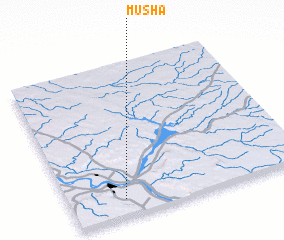 Places with similar names to Mūshā, Egypt ::
Disclaimer :: Information on this page comes without warranty of any kind |
||
|
Where is Mūshā? Elevation and coordinates ::
Latitude (lat): 27°6'45"N Longitude (lon): 31°14'5"E
Elevation (approx.): 62m (map arrows pan, magnifying glasses zoom) |
||
|
Visiting Mūshā? Hotel/Accommodation ::
Book a hotel in Mūshā Travel Guide ::
Buy a travel guide for Egypt rental cars ::
car rental offers GPS waypoint ::
download a GPX waypoint (PoI) of Mūshā for your GPS receiver
|
||