|
search place name
|
||
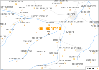
Kalimanitsa (Bulgaria)Kalimanitsa is a town in Bulgaria. An overview map of the region around Kalimanitsa is displayed below.
regional and 3d topo map of Kalimanitsa, Bulgaria ::
Kalimanitsa airports ::
The nearest airport is SOF - Sofia, located 75.6 km south of Kalimanitsa.
Other airports nearby include INI - Nis (105.3 km west), CRA - Craiova (122.9 km north east), SKP - Skopje (198.7 km south west), PDV - Plovdiv (199.1 km south east), Nearby towns ::
Zhivovtsi (3.8km north) //
Borovtsi (3.5km south east) //
Gaganitsa (4.0km south west) //
Bistrilitsa (3.9km west) //
Gorno Tserovene (6.8km north west) //
Blagovo (5.6km east) //
Kostentsi (7.6km south) //
Komarevo (7.9km south) //
Balyuvitsa (7.1km south east) //
Leskovets (7.0km south west) //
Kvartal Mala Kutlovitsa (7.4km north east) //
Bokilovtsi (8.8km south east) //
Montana (9.2km north east) //
Kotenovtsi (9.5km south west) //
[all distances 'as the bird flies' and approximate]  Places with similar names to Kalimanitsa, Bulgaria ::
// Clements (US)
// Colmnitz (DE)
// Colmnitz (DE)
// Clements (US)
// Clements (US)
// Golemantsi (BG)
// Kalimantsi (BG)
// Klimenitsy (RU)
// Clements (US)
// Clements (US)
Disclaimer :: Information on this page comes without warranty of any kind |
||
|
Where is Kalimanitsa? Elevation and coordinates ::
Latitude (lat): 43°20'57"N Longitude (lon): 23°9'6"E
Elevation (approx.): 202m (map arrows pan, magnifying glasses zoom) |
||
|
Visiting Kalimanitsa? Hotel/Accommodation ::
Book a hotel in Kalimanitsa Travel Guide ::
Buy a travel guide for Bulgaria rental cars ::
car rental offers GPS waypoint ::
download a GPX waypoint (PoI) of Kalimanitsa for your GPS receiver
|
||