|
search place name
|
||
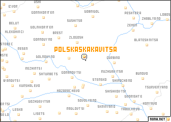
Polska Skakavitsa (Bulgaria)Polska Skakavitsa is a town in Bulgaria. An overview map of the region around Polska Skakavitsa is displayed below.
regional and 3d topo map of Polska Skakavitsa, Bulgaria ::
Polska Skakavitsa airports ::
The nearest airport is SOF - Sofia, located 68.9 km north east of Polska Skakavitsa.
Other airports nearby include SKP - Skopje (99.3 km south west), INI - Nis (121.3 km north west), PRN - Pristina (134.2 km west), OHD - Ohrid (210.2 km south west), Nearby towns ::
Poletintsi (2.8km west) //
Zlogosh (4.3km north) //
Goranovtsi (4.2km south west) //
Dragovishtitsa (5.3km south) //
Yamborano (5.8km south) //
Stensko (5.7km south east) //
Perivol (6.1km south) //
Gŭrbino (4.7km east) //
Rŭzhdavitsa (5.6km south east) //
Razhdavitsa (5.6km south east) //
Brest (6.7km north west) //
Sushitsa (7.9km north) //
Mazarachevo (8.1km south) //
Dolno Uyno (6.4km west) //
Shtŭrbets (7.1km south west) //
Shipochano (8.2km south east) //
Shishkovtsi (9.2km south east) //
[all distances 'as the bird flies' and approximate] 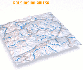 Places with similar names to Polska Skakavitsa, Bulgaria :: Disclaimer :: Information on this page comes without warranty of any kind |
||
|
Where is Polska Skakavitsa? Elevation and coordinates ::
Latitude (lat): 42°25'7"N Longitude (lon): 22°39'19"E
Elevation (approx.): 855m (map arrows pan, magnifying glasses zoom) |
||
|
Visiting Polska Skakavitsa? Hotel/Accommodation ::
Book a hotel in Polska Skakavitsa Travel Guide ::
Buy a travel guide for Bulgaria rental cars ::
car rental offers GPS waypoint ::
download a GPX waypoint (PoI) of Polska Skakavitsa for your GPS receiver
|
||