|
search place name
|
||
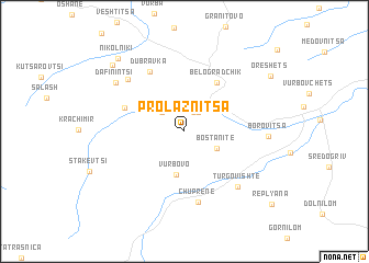
Prolaznitsa (Vidin, Bulgaria)Prolaznitsa is a town in the Vidin region of Bulgaria. An overview map of the region around Prolaznitsa is displayed below.
regional and 3d topo map of Prolaznitsa, Bulgaria ::
Prolaznitsa airports ::
The nearest airport is INI - Nis, located 70.3 km south west of Prolaznitsa.
Other airports nearby include SOF - Sofia (116.0 km south east), CRA - Craiova (128.5 km north east), PRN - Pristina (173.0 km south west), SKP - Skopje (198.9 km south west), Nearby towns ::
Chiflik (2.0km north) //
Dolni Chiflik (2.2km north east) //
Gorni Chiflik (2.6km north west) //
Bostanite (3.0km south east) //
Vŭrbovo (4.4km south) //
Belogradchik (5.5km north east) //
Prauzhda (5.0km north west) //
Dŭbravka (6.6km north) //
Chuprene (7.2km south) //
Pŭrvolovski Kolibi (6.7km north west) //
Tŭrgovishte (6.9km south east) //
Borovitsa (6.2km east) //
Dafinintsi (7.1km north west) //
Granichak (8.6km north west) //
Nikolniki (8.9km north west) //
Oreshets (8.5km north east) //
[all distances 'as the bird flies' and approximate] 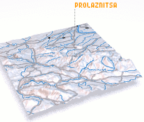 Places with similar names to Prolaznitsa, Bulgaria :: Disclaimer :: Information on this page comes without warranty of any kind |
||
|
Where is Prolaznitsa? Elevation and coordinates ::
Latitude (lat): 43°34'57"N Longitude (lon): 22°39'14"E
Elevation (approx.): 472m (map arrows pan, magnifying glasses zoom) |
||
|
Visiting Prolaznitsa? Hotel/Accommodation ::
Book a hotel in Prolaznitsa Travel Guide ::
Buy a travel guide for Bulgaria rental cars ::
car rental offers GPS waypoint ::
download a GPX waypoint (PoI) of Prolaznitsa for your GPS receiver
|
||