|
search place name
|
||
Simitli (Blagoevgrad, Bulgaria)Simitli is a town in the Blagoevgrad region of Bulgaria. An overview map of the region around Simitli is displayed below.
regional and 3d topo map of Simitli, Bulgaria ::

Simitli airports ::
The nearest airport is SOF - Sofia, located 93.3 km north of Simitli.
Other airports nearby include SKP - Skopje (124.3 km west), PDV - Plovdiv (145.2 km east), SKG - Thessaloniki Makedonia (151.9 km south), KVA - Kavala Megas Alexandros Intl (165.5 km south east), Nearby towns ::
Cherniche (4.0km south) //
Polena (4.0km south) //
Dokatichevo (4.1km west) //
Troskovo (5.6km south west) //
Sushitsa (6.2km south west) //
Brezhani (5.8km east) //
Poleto (5.8km east) //
Zheleznitsa (7.8km north west) //
[all distances 'as the bird flies' and approximate] 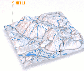 Places with similar names to Simitli, Bulgaria ::
// Smedley (US)
// Semitela (PT)
// Žemaitėliai (LT)
// Žemaitėliai (LT)
// Sametli (TR)
// Semetali (TR)
// Semetli (TR)
// Sömetli (TR)
// Zamdela (ZA)
// Smittle (US)
Disclaimer :: Information on this page comes without warranty of any kind |
||
|
Where is Simitli? Elevation and coordinates ::
Latitude (lat): 41°53'0"N Longitude (lon): 23°7'0"E
Elevation (approx.): 282m (map arrows pan, magnifying glasses zoom) |
||
|
Visiting Simitli? Hotel/Accommodation ::
Book a hotel in Simitli Travel Guide ::
Buy a travel guide for Bulgaria rental cars ::
car rental offers GPS waypoint ::
download a GPX waypoint (PoI) of Simitli for your GPS receiver
|
||