|
search place name
|
||
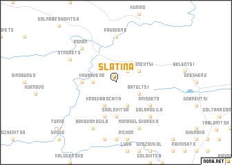
Slatina (Bulgaria)Slatina is a town in Bulgaria. An overview map of the region around Slatina is displayed below.
regional and 3d topo map of Slatina, Bulgaria ::
Slatina airports ::
The nearest airport is SOF - Sofia, located 64.2 km south west of Slatina.
Other airports nearby include CRA - Craiova (135.5 km north), PDV - Plovdiv (135.7 km south east), GOZ - Gorna Orechovica Gorna Oryahovitsa (142.2 km east), Nearby towns ::
Mishkarete (2.3km north east) //
Khubavene (2.7km west) //
Dŭbravata (3.9km south) //
Stoyanovtsi (3.3km north east) //
Batultsi (3.3km south east) //
Kraeva Bachiya (3.9km south) //
Karash (4.1km west) //
Smolevitsa (5.6km south) //
Markovo Ravnishte (5.7km south) //
Prisoeto (5.5km south east) //
Radovene (7.4km north) //
Roman (6.9km north west) //
Gola Mogila (6.9km south east) //
Budzhov Dol (6.9km south east) //
Manaselska Reka (7.9km south) //
Strupets (6.6km north west) //
Bakova Mogila (7.9km south) //
[all distances 'as the bird flies' and approximate]  Places with similar names to Slatina, Bulgaria ::
Disclaimer :: Information on this page comes without warranty of any kind |
||
|
Where is Slatina? Elevation and coordinates ::
Latitude (lat): 43°6'0"N Longitude (lon): 23°58'0"E
Elevation (approx.): 332m (map arrows pan, magnifying glasses zoom) |
||
|
Visiting Slatina? Hotel/Accommodation ::
Book a hotel in Slatina Travel Guide ::
Buy a travel guide for Bulgaria rental cars ::
car rental offers GPS waypoint ::
download a GPX waypoint (PoI) of Slatina for your GPS receiver
|
||