|
search place name
|
||
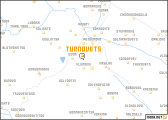
Tŭrnovets (Bulgaria)Tŭrnovets is a town in Bulgaria. An overview map of the region around Tŭrnovets is displayed below.
regional and 3d topo map of Tŭrnovets, Bulgaria ::
Tŭrnovets airports ::
The nearest airport is SOF - Sofia, located 49.6 km north east of Tŭrnovets.
Other airports nearby include SKP - Skopje (119.1 km south west), INI - Nis (132.8 km north west), PRN - Pristina (155.4 km west), PDV - Plovdiv (164.7 km east), Nearby towns ::
Klenovik (1.9km south) //
Kolosh (2.1km south east) //
Izvor (1.9km west) //
Zhitusha (2.3km south east) //
Kandzhulitsa (3.7km north) //
Negovantsi (3.3km north east) //
Petrunovo (4.0km north) //
Kasilag (3.9km south east) //
Zhedna (4.5km south east) //
Kalugerski Chiflik (5.7km north) //
Kosharite (5.8km north) //
Debeli Lag (4.9km north west) //
Uglyartsi (6.2km south west) //
Boboratsi (5.8km north east) //
Priboy (7.0km north) //
Potsŭrnentsi (6.8km north) //
Kosharite (6.7km north east) //
Golema Fucha (6.9km south) //
Egŭlnitsa (6.6km north west) //
Mala Fucha (8.9km south) //
Babino (9.6km south east) //
[all distances 'as the bird flies' and approximate] 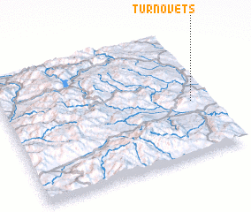 Places with similar names to Tŭrnovets, Bulgaria ::
// Tarnefitz (DE)
// Drenovets (BG)
// Drenovitsa (BG)
// Tŭrnovtsa (BG)
// Tŭrnovtsi (BG)
// Tŭrnovtsi (BG)
// Ternovitsa (UA)
// Ternovitsa (UA)
Disclaimer :: Information on this page comes without warranty of any kind |
||
|
Where is Tŭrnovets? Elevation and coordinates ::
Latitude (lat): 42°26'0"N Longitude (lon): 22°55'0"E
Elevation (approx.): 653m (map arrows pan, magnifying glasses zoom) |
||
|
Visiting Tŭrnovets? Hotel/Accommodation ::
Book a hotel in Tŭrnovets Travel Guide ::
Buy a travel guide for Bulgaria rental cars ::
car rental offers GPS waypoint ::
download a GPX waypoint (PoI) of Tŭrnovets for your GPS receiver
|
||