|
search place name
|
||
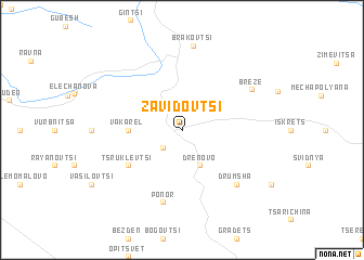
Zavidovtsi (Bulgaria)Zavidovtsi is a town in Bulgaria. An overview map of the region around Zavidovtsi is displayed below.
regional and 3d topo map of Zavidovtsi, Bulgaria ::
Zavidovtsi airports ::
The nearest airport is SOF - Sofia, located 38.3 km south east of Zavidovtsi.
Other airports nearby include INI - Nis (112.5 km west), CRA - Craiova (159.8 km north), SKP - Skopje (169.4 km south west), PDV - Plovdiv (172.8 km south east), Nearby towns ::
Manastirishte (2.4km north) //
Buchin Prokhod (2.3km south west) //
Drenovo (3.9km south) //
Vakarel (4.1km west) //
Raetska (4.1km west) //
Shuma (4.1km west) //
Stranska (4.1km west) //
Tsrŭklevtsi (5.5km south west) //
Ponor (7.5km south) //
Drŭmsha (6.9km south east) //
Breze (6.6km north east) //
Brakʼovtsi (8.7km north) //
[all distances 'as the bird flies' and approximate] 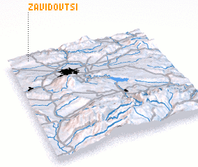 Places with similar names to Zavidovtsi, Bulgaria ::
// Svidovets (UA)
Disclaimer :: Information on this page comes without warranty of any kind |
||
|
Where is Zavidovtsi? Elevation and coordinates ::
Latitude (lat): 42°59'0"N Longitude (lon): 23°9'0"E
Elevation (approx.): 747m (map arrows pan, magnifying glasses zoom) |
||
|
Visiting Zavidovtsi? Hotel/Accommodation ::
Book a hotel in Zavidovtsi Travel Guide ::
Buy a travel guide for Bulgaria rental cars ::
car rental offers GPS waypoint ::
download a GPX waypoint (PoI) of Zavidovtsi for your GPS receiver
|
||