|
search place name
|
||
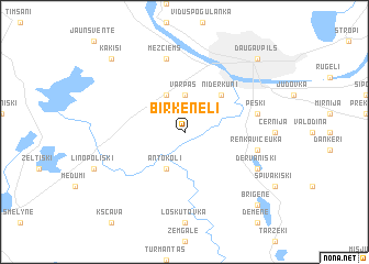
Birkeneļi (Daugavpils Rajons, Latvia)Birkeneļi is a town in the Daugavpils Rajons region of Latvia. An overview map of the region around Birkeneļi is displayed below.
regional and 3d topo map of Birkeneļi, Latvia ::
Birkeneļi airports ::
The nearest airport is MHP - Minsk 1, located 228.0 km south of Birkeneļi.
Other airports nearby include MSQ - Minsk 2 (237.6 km south east), Nearby towns ::
Vārpas (3.7km north) //
Kalkūne (3.8km north) //
Antokoļi (3.9km south) //
Grīva (4.3km north east) //
Nīderkūni (4.3km north east) //
Peski (4.6km north east) //
Mežciems (7.5km north) //
Renkavičeuka (4.6km south east) //
Dervaniški (5.6km south east) //
Daugavpils (8.5km north east) //
Briģene (8.5km south east) //
Kaķīši (8.5km north west) //
[all distances 'as the bird flies' and approximate] 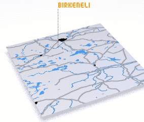 Places with similar names to Birkeneļi, Latvia ::
// Brignole (IT)
// Brugnola (IT)
// Bărăganul (RO)
// Bărcanele (RO)
// Borakanelo (ZA)
// Brookneal (US)
// Borakanelo (BW)
// Bracknell (AU)
// Brucknell (AU)
// Bracknell (GB)
Disclaimer :: Information on this page comes without warranty of any kind |
||
|
Where is Birkeneļi? Elevation and coordinates ::
Latitude (lat): 55°49'0"N Longitude (lon): 26°28'0"E
Elevation (approx.): 102m (map arrows pan, magnifying glasses zoom) |
||
|
Visiting Birkeneļi? Hotel/Accommodation ::
Book a hotel in Birkeneļi Travel Guide ::
Buy a travel guide for Latvia rental cars ::
car rental offers GPS waypoint ::
download a GPX waypoint (PoI) of Birkeneļi for your GPS receiver
|
||