|
search place name
|
||
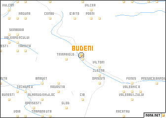
Budeni (Covurlui, Romania)Budeni is a town in the Covurlui region of Romania. An overview map of the region around Budeni is displayed below.
regional and 3d topo map of Budeni, Romania ::
Budeni airports ::
The nearest airport is CLJ - Cluj-napoca Cluj Napoca, located 80.5 km north east of Budeni.
Other airports nearby include SBZ - Sibiu (81.2 km south east), TGM - Tirgu Mures Vidrasau (101.1 km east), CSB - Caransebes (108.7 km south west), OMR - Oradea (138.2 km north west), Nearby towns ::
Izvoru Ampoiului (0.0km north) //
Ruşi (0.0km north) //
Dobrot (0.0km north) //
Boteşti (0.0km north) //
Dealu Roatei (0.0km north) //
Trîmpaiele (2.6km west) //
Vîltori (3.2km south east) //
Zlatna (4.5km south east) //
Dumbrava (4.5km south east) //
Pîrău Gruiului (4.5km south east) //
Pirita (4.5km south east) //
Podu lui Pal (4.5km south east) //
Runc (4.5km south east) //
Suseni (4.5km south east) //
Valea lui Paul (4.5km south east) //
Opreşti (6.1km south east) //
Almaşu Mare (6.8km south west) //
Cheile Cibului (6.8km south west) //
Nădăştia (8.4km south west) //
[all distances 'as the bird flies' and approximate] 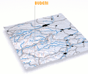 Places with similar names to Budeni, Romania ::
Disclaimer :: Information on this page comes without warranty of any kind |
||
|
Where is Budeni? Elevation and coordinates ::
Latitude (lat): 46°9'0"N Longitude (lon): 23°11'0"E
Elevation (approx.): 715m (map arrows pan, magnifying glasses zoom) |
||
|
Visiting Budeni? Hotel/Accommodation ::
Book a hotel in Budeni Travel Guide ::
Buy a travel guide for Romania rental cars ::
car rental offers GPS waypoint ::
download a GPX waypoint (PoI) of Budeni for your GPS receiver
|
||