|
search place name
|
||
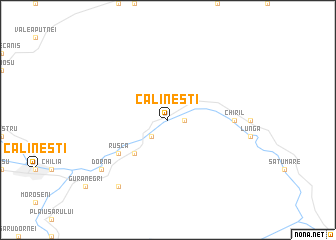
Călineşti (Covurlui, Romania)Călineşti is a town in the Covurlui region of Romania. An overview map of the region around Călineşti is displayed below.
regional and 3d topo map of Călineşti, Romania ::
Călineşti airports ::
The nearest airport is SCV - Suceava Stefan Cel Mare, located 71.8 km north east of Călineşti.
Other airports nearby include TGM - Tirgu Mures Vidrasau (132.7 km south west), BCM - Bacau (145.1 km south east), CLJ - Cluj-napoca Cluj Napoca (153.7 km south west), SBZ - Sibiu (209.4 km south west), Nearby towns ::
Zugreni (1.3km east) //
Sunători (2.2km south west) //
Osoiu (4.5km south west) //
Ruşca (5.3km south west) //
Gheorghiţeni (5.3km south west) //
Chiril (5.0km east) //
Arama (5.0km east) //
Arin (7.5km south west) //
Dorna (7.5km south west) //
Cozăneşti (8.3km south west) //
[all distances 'as the bird flies' and approximate]  Places with similar names to Călineşti, Romania ::
// Glen City (US)
// Glenzaida (US)
// Glinzt (DE)
// Kleinosida (DE)
// Kleinseidau (DE)
// Klein Uhyst (DE)
// Coloncito (PA)
// Kolonia Sady (PL)
// Kalnasati (LV)
// Călineşti (RO)
Disclaimer :: Information on this page comes without warranty of any kind |
||
|
Where is Călineşti? Elevation and coordinates ::
Latitude (lat): 47°24'0"N Longitude (lon): 25°30'0"E
Elevation (approx.): 917m (map arrows pan, magnifying glasses zoom) |
||
|
Visiting Călineşti? Hotel/Accommodation ::
Book a hotel in Călineşti Travel Guide ::
Buy a travel guide for Romania rental cars ::
car rental offers GPS waypoint ::
download a GPX waypoint (PoI) of Călineşti for your GPS receiver
|
||