|
search place name
|
||
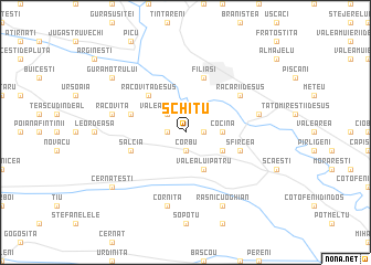
Schitu (Covurlui, Romania)Schitu is a town in the Covurlui region of Romania. An overview map of the region around Schitu is displayed below.
regional and 3d topo map of Schitu, Romania ::
Schitu airports ::
The nearest airport is CRA - Craiova, located 37.0 km south east of Schitu.
Other airports nearby include CSB - Caransebes (141.9 km north west), SBZ - Sibiu (150.3 km north), INI - Nis (184.9 km south west), SOF - Sofia (200.7 km south), Nearby towns ::
Valea Fîntînilor (1.3km west) //
Braloştiţa (1.3km east) //
Racoviţa din Faţă (1.3km east) //
Corbu (1.9km south) //
Valea lui Stroe (2.3km north west) //
Cocina (2.6km east) //
Ochişoru (3.2km south east) //
Valea lui Pătru (3.9km south) //
Bîlta (4.6km north west) //
Racoviţa de Jos (4.6km north west) //
Racoviţa de Sus (4.6km north west) //
Filiaşi (5.7km north) //
Sfîrcea (4.4km south east) //
Ciocanele (4.4km north west) //
Salcia (4.4km south west) //
Răcarii de Sus (5.4km north east) //
Corniţa (7.5km south) //
Cotina Schitu (5.6km west) //
Cotina (5.6km west) //
Racoviţa (5.6km west) //
Faţa Racoviţei (5.6km west) //
Răcarii de Jos (5.6km east) //
Rasnicu Oghian (7.9km south) //
Cernăteşti (7.7km south west) //
Gura Motrului (7.7km north west) //
[all distances 'as the bird flies' and approximate]  Places with similar names to Schitu, Romania ::
Disclaimer :: Information on this page comes without warranty of any kind |
||
|
Where is Schitu? Elevation and coordinates ::
Latitude (lat): 44°30'0"N Longitude (lon): 23°30'0"E
Elevation (approx.): 185m (map arrows pan, magnifying glasses zoom) |
||
|
Visiting Schitu? Hotel/Accommodation ::
Book a hotel in Schitu Travel Guide ::
Buy a travel guide for Romania rental cars ::
car rental offers GPS waypoint ::
download a GPX waypoint (PoI) of Schitu for your GPS receiver
|
||