|
search place name
|
||
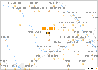
Solonţ (Covurlui, Romania)Solonţ is a town in the Covurlui region of Romania. An overview map of the region around Solonţ is displayed below.
regional and 3d topo map of Solonţ, Romania ::
Solonţ airports ::
The nearest airport is BCM - Bacau, located 30.4 km east of Solonţ.
Other airports nearby include IAS - Iasi (109.4 km north east), SCV - Suceava Stefan Cel Mare (127.1 km north), OTP - Bucharest Henri Coanda (222.2 km south), Nearby towns ::
Baia de Petrol (0.0km north) //
Stăneşti (1.9km south) //
Cucueţi (3.9km north) //
Borzeşti (3.2km north east) //
Măgireşti (4.5km south east) //
Tazlău de Jos (3.8km west) //
Prăjeşti (5.6km south) //
Valea Arinilor (5.7km south) //
Sărata (4.2km north east) //
Timăreşti (5.3km north east) //
Găzărie (7.4km south) //
Rusăeşti (7.4km south) //
Poarta-Leontineşti (5.4km east) //
Băhnăşeni (5.4km east) //
Prohozeşti (7.5km south) //
Cătunu-Şesuri (6.7km south east) //
Şesuri (6.7km south east) //
Negreni (7.8km south) //
Lucăceşti (7.8km south) //
Cornet (7.5km south east) //
Lereni (8.3km south east) //
Bucşeşti (8.3km south east) //
Corneţelu (8.3km south east) //
Ludaşi (8.3km north east) //
[all distances 'as the bird flies' and approximate] 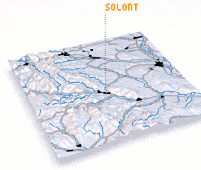 Places with similar names to Solonţ, Romania ::
Disclaimer :: Information on this page comes without warranty of any kind |
||
|
Where is Solonţ? Elevation and coordinates ::
Latitude (lat): 46°33'0"N Longitude (lon): 26°31'0"E
Elevation (approx.): 567m (map arrows pan, magnifying glasses zoom) |
||
|
Visiting Solonţ? Hotel/Accommodation ::
Book a hotel in Solonţ Travel Guide ::
Buy a travel guide for Romania rental cars ::
car rental offers GPS waypoint ::
download a GPX waypoint (PoI) of Solonţ for your GPS receiver
|
||