|
search place name
|
||
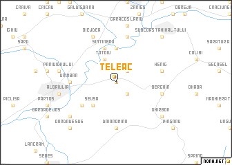
Teleac (Covurlui, Romania)Teleac is a town in the Covurlui region of Romania. An overview map of the region around Teleac is displayed below.
regional and 3d topo map of Teleac, Romania ::
Teleac airports ::
The nearest airport is SBZ - Sibiu, located 46.7 km south east of Teleac.
Other airports nearby include TGM - Tirgu Mures Vidrasau (71.6 km north east), CLJ - Cluj-napoca Cluj Napoca (78.0 km north), CSB - Caransebes (132.4 km south west), OMR - Oradea (171.1 km north west), Nearby towns ::
Morăreşti (0.0km north) //
Hăpria (0.0km north) //
Straja (2.3km south east) //
Dumitra (2.3km north east) //
Totoiu (3.9km north) //
Şeuşa (4.5km south west) //
Galtiu (5.6km north) //
Sîntimbru (5.7km north) //
Ciugud (5.3km south west) //
Daia Romînă (7.4km south) //
Drîmbar (5.1km west) //
Berghin (5.5km east) //
Henig (5.5km east) //
Coşlariu (7.5km north) //
Oiejdea (7.8km north) //
Ghirbom (7.6km south east) //
Limba (7.6km south west) //
Oarda de Sus (9.0km south west) //
Coasta Mihalţului (9.0km north east) //
Subcoasta Mihalţului (9.0km north east) //
Mihalţ (9.0km north east) //
[all distances 'as the bird flies' and approximate]  Places with similar names to Teleac, Romania ::
Disclaimer :: Information on this page comes without warranty of any kind |
||
|
Where is Teleac? Elevation and coordinates ::
Latitude (lat): 46°5'0"N Longitude (lon): 23°40'0"E
Elevation (approx.): 288m (map arrows pan, magnifying glasses zoom) |
||
|
Visiting Teleac? Hotel/Accommodation ::
Book a hotel in Teleac Travel Guide ::
Buy a travel guide for Romania rental cars ::
car rental offers GPS waypoint ::
download a GPX waypoint (PoI) of Teleac for your GPS receiver
|
||