|
search place name
|
||
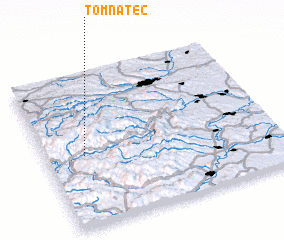
Tomnatec (Covurlui, Romania)Tomnatec is a town in the Covurlui region of Romania. An overview map of the region around Tomnatec is displayed below.
regional and 3d topo map of Tomnatec, Romania ::

Tomnatec airports ::
The nearest airport is CLJ - Cluj-napoca Cluj Napoca, located 53.3 km north east of Tomnatec.
Other airports nearby include TGM - Tirgu Mures Vidrasau (95.7 km east), SBZ - Sibiu (104.1 km south east), OMR - Oradea (114.8 km north west), BAY - Baia Mare Tautii Magheraus (134.5 km north), Nearby towns ::
 Places with similar names to Tomnatec, Romania ::
// Tomnatec (RO)
// Tomnatic (RO)
// Tomnatic (RO)
// Damandigui (BF)
// Tamentica (CL)
// Tombon Tagao (NE)
// Damandougou (GN)
// Diomandougou (GN)
// Domanidougou (GN)
// Téménedougou (GN)
Disclaimer :: Information on this page comes without warranty of any kind |
||
|
Where is Tomnatec? Elevation and coordinates ::
Latitude (lat): 46°28'0"N Longitude (lon): 23°10'0"E
Elevation (approx.): 1227m (map arrows pan, magnifying glasses zoom) |
||
|
Visiting Tomnatec? Hotel/Accommodation ::
Book a hotel in Tomnatec Travel Guide ::
Buy a travel guide for Romania rental cars ::
car rental offers GPS waypoint ::
download a GPX waypoint (PoI) of Tomnatec for your GPS receiver
|
||