|
search place name
|
||
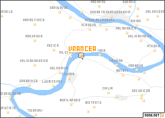
Vrancea (Mehedinţi, Romania)Vrancea is a town in the Mehedinţi region of Romania. An overview map of the region around Vrancea is displayed below.
regional and 3d topo map of Vrancea, Romania ::
Vrancea airports ::
The nearest airport is CSB - Caransebes, located 100.9 km north of Vrancea.
Other airports nearby include CRA - Craiova (105.8 km east), INI - Nis (146.9 km south west), TSR - Timisoara Traian Vuia (171.9 km north west), SBZ - Sibiu (181.1 km north east), Nearby towns ::
Milutinovac (2.0km west) //
Vajuga (2.9km east) //
Crivina (4.9km south west) //
Velesnica (4.8km south west) //
Rečica (5.1km north west) //
Kladovo (6.9km north) //
Tismana (5.6km east) //
Kostol (7.7km north east) //
Schela Cladovei (8.4km north) //
Ljubičevac (7.7km south west) //
(( Chilia )) (8.6km south east) //
Devesel (10.1km south east) //
[all distances 'as the bird flies' and approximate]  Places with similar names to Vrancea, Romania ::
Disclaimer :: Information on this page comes without warranty of any kind |
||
|
Where is Vrancea? Elevation and coordinates ::
Latitude (lat): 44°32'43"N Longitude (lon): 22°35'53"E
Elevation (approx.): 48m (map arrows pan, magnifying glasses zoom) |
||
|
Visiting Vrancea? Hotel/Accommodation ::
Book a hotel in Vrancea Travel Guide ::
Buy a travel guide for Romania rental cars ::
car rental offers GPS waypoint ::
download a GPX waypoint (PoI) of Vrancea for your GPS receiver
|
||