|
search place name
|
||
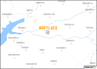
Börtlüce (Manisa, Turkey)Börtlüce is a town in the Manisa region of Turkey. An overview map of the region around Börtlüce is displayed below.
regional and 3d topo map of Börtlüce, Turkey ::
Börtlüce airports ::
The nearest airport is BZI - Balikesir, located 116.4 km north west of Börtlüce.
Other airports nearby include ADB - Izmir Adnan Menderes (129.0 km west), IGL - Izmir Cigli (135.2 km west), DNZ - Denizli Cardak (142.4 km south east), MJT - Mytilini Mitilini (173.9 km west), Nearby towns ::
Gökveliler (6.8km north) //
Yabacı (6.6km north west) //
Karacaibrahim (6.8km north west) //
Emre (7.4km south) //
Ayazören (7.5km south east) //
Encekler (6.9km north east) //
Hamidiye (7.7km south east) //
Tahtacı (8.7km north west) //
Kenger (9.3km south west) //
Borlu (10.0km north west) //
[all distances 'as the bird flies' and approximate] 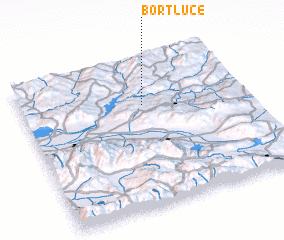 Places with similar names to Börtlüce, Turkey ::
// Bartelso (US)
// Britelos (PT)
// Bratilës (AL)
// Bērtulaiši (LV)
// Bērtulaiši (LV)
// Bardullas (ES)
// Bord Lūseh (IR)
// Bartles (US)
// Baratlici (MK)
// Barretillas (MX)
Disclaimer :: Information on this page comes without warranty of any kind |
||
|
Where is Börtlüce? Elevation and coordinates ::
Latitude (lat): 38°41'19"N Longitude (lon): 28°32'47"E
Elevation (approx.): 557m (map arrows pan, magnifying glasses zoom) |
||
|
Visiting Börtlüce? Hotel/Accommodation ::
Book a hotel in Börtlüce Travel Guide ::
Buy a travel guide for Turkey rental cars ::
car rental offers GPS waypoint ::
download a GPX waypoint (PoI) of Börtlüce for your GPS receiver
|
||