|
search place name
|
||
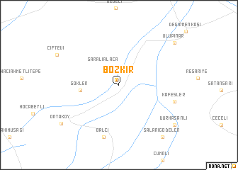
Bozkır (Sivas, Turkey)Bozkır is a town in the Sivas region of Turkey. An overview map of the region around Bozkır is displayed below.
regional and 3d topo map of Bozkır, Turkey ::
Bozkır airports ::
The nearest airport is ASR - Kayseri Erkilet, located 119.4 km east of Bozkır.
Other airports nearby include KYA - Konya (163.4 km south west), ESB - Ankara Esenboga (177.3 km north west), ANK - Ankara Etimesgut (178.4 km north west), ADA - Adana (225.1 km south east), Nearby towns ::
Saralıalaca (3.5km north west) //
Gökler (4.8km west) //
Balcı (8.4km south) //
Kafesler (7.3km east) //
Salarıgödeler (9.8km south east) //
Durhasanlı (9.3km south east) //
Ulupınar (9.5km north east) //
[all distances 'as the bird flies' and approximate] 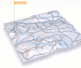 Places with similar names to Bozkır, Turkey ::
// Bou Skour (MA)
// Bou Ousakkour (MA)
// Baskura (ET)
// Bosacker (DE)
// Boschiere (IT)
// Bāsakrah (IQ)
// Bessaker (NO)
// Besiekiery (PL)
// Basquira (BO)
// Buzgarë (AL)
Disclaimer :: Information on this page comes without warranty of any kind |
||
|
Where is Bozkır? Elevation and coordinates ::
Latitude (lat): 38°47'26"N Longitude (lon): 34°7'18"E
Elevation (approx.): 1072m (map arrows pan, magnifying glasses zoom) |
||
|
Visiting Bozkır? Hotel/Accommodation ::
Book a hotel in Bozkır Travel Guide ::
Buy a travel guide for Turkey rental cars ::
car rental offers GPS waypoint ::
download a GPX waypoint (PoI) of Bozkır for your GPS receiver
|
||