|
search place name
|
||
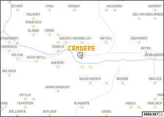
Çamdere (Tokat, Turkey)Çamdere is a town in the Tokat region of Turkey. An overview map of the region around Çamdere is displayed below.
regional and 3d topo map of Çamdere, Turkey ::
Çamdere airports ::
The nearest airport is VAS - Sivas, located 78.1 km south east of Çamdere.
Other airports nearby include MZH - Merzifon (90.0 km north west), ASR - Kayseri Erkilet (161.8 km south), MLX - Malatya Erhac (256.4 km south east), Nearby towns ::
Yaylakent (1.9km south) //
Mertekli (2.3km south east) //
Karabalçık (3.7km north) //
Göçenli (4.7km north west) //
Devecikargın (5.7km south) //
Temecik (4.6km north west) //
Kuruçay (4.6km south west) //
Bayırlı (5.6km north east) //
Çakırcalı (5.6km north west) //
Ahmetdanişment (7.0km south east) //
Armutalan (7.0km north west) //
Arpacıkaraçay (8.5km south west) //
Çapak (7.9km north west) //
[all distances 'as the bird flies' and approximate] 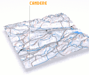 Places with similar names to Çamdere, Turkey ::
// Quem Diria (BR)
// Gum Tree (US)
// Kawm Baddār (EG)
// Kawm Badr (EG)
// Çamdere (TR)
// Çamdere (TR)
// Camidere (TR)
// Kumdere (TR)
// Kumatyr' (RU)
// Kumdora (RU)
Disclaimer :: Information on this page comes without warranty of any kind |
||
|
Where is Çamdere? Elevation and coordinates ::
Latitude (lat): 40°9'0"N Longitude (lon): 36°6'0"E
Elevation (approx.): 1049m (map arrows pan, magnifying glasses zoom) |
||
|
Visiting Çamdere? Hotel/Accommodation ::
Book a hotel in Çamdere Travel Guide ::
Buy a travel guide for Turkey rental cars ::
car rental offers GPS waypoint ::
download a GPX waypoint (PoI) of Çamdere for your GPS receiver
|
||