|
search place name
|
||
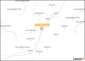
Darıdere (Kayseri, Turkey)Darıdere is a town in the Kayseri region of Turkey. An overview map of the region around Darıdere is displayed below.
regional and 3d topo map of Darıdere, Turkey ::
Darıdere airports ::
The nearest airport is ASR - Kayseri Erkilet, located 93.2 km north west of Darıdere.
Other airports nearby include MLX - Malatya Erhac (140.7 km east), VAS - Sivas (156.8 km north), ADA - Adana Incirlik Ab (184.7 km south west), GZT - Gaziantep Oguzeli (187.7 km south east), Nearby towns ::
Altısöğüt (2.8km west) //
Sarız (4.7km north east) //
Fettahdere (4.1km west) //
Tavla (5.4km south east) //
Çörekdere (6.7km north) //
Karayurt (6.0km south west) //
İncedere (7.4km north east) //
Ördekli (8.4km south) //
Kuşçu (8.1km north east) //
Mollahüseyinler (10.7km south west) //
[all distances 'as the bird flies' and approximate]  Places with similar names to Darıdere, Turkey ::
// Taratara (BO)
// Dar Dar (MA)
// Dardara (MA)
// Douar Drâa (MA)
// Douar Draaoua (MA)
// Tiratira (BO)
// Torotoro (BO)
// Tretiy Yar (RU)
// Tǝrtǝr (AZ)
// Dardara (PH)
Disclaimer :: Information on this page comes without warranty of any kind |
||
|
Where is Darıdere? Elevation and coordinates ::
Latitude (lat): 38°26'26"N Longitude (lon): 36°28'46"E
Elevation (approx.): 1573m (map arrows pan, magnifying glasses zoom) |
||
|
Visiting Darıdere? Hotel/Accommodation ::
Book a hotel in Darıdere Travel Guide ::
Buy a travel guide for Turkey rental cars ::
car rental offers GPS waypoint ::
download a GPX waypoint (PoI) of Darıdere for your GPS receiver
|
||