|
search place name
|
||
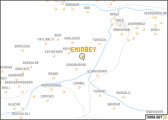
Eminbey (Ardahan, Turkey)Eminbey is a town in the Ardahan region of Turkey. An overview map of the region around Eminbey is displayed below.
regional and 3d topo map of Eminbey, Turkey ::
Eminbey airports ::
The nearest airport is ERZ - Erzurum, located 223.4 km south west of Eminbey.
Nearby towns ::
Gümüşkavak (2.4km south west) //
Armutver (3.0km north) //
Kayınlı (3.0km north west) //
Dzhakismani (4.0km south east) //
Kumlukoz (4.5km north west) //
Türközü (4.4km north east) //
Çambel (6.2km south) //
Çayırçimen (5.1km west) //
Erim (6.4km north west) //
Posof (6.5km south west) //
Alköy (7.9km south west) //
Yeniköy (8.3km south) //
Yaylaaltı (7.4km north west) //
Aşağıkonağı (8.5km south west) //
Tsarbastʼumani (9.2km north east) //
Naokhrebi (8.6km north east) //
Vale (10.0km north east) //
Süngülü (10.5km south east) //
[all distances 'as the bird flies' and approximate] 
Disclaimer :: Information on this page comes without warranty of any kind |
||
|
Where is Eminbey? Elevation and coordinates ::
Latitude (lat): 41°32'50"N Longitude (lon): 42°47'26"E
Elevation (approx.): 1537m (map arrows pan, magnifying glasses zoom) |
||
|
Visiting Eminbey? Hotel/Accommodation ::
Book a hotel in Eminbey Travel Guide ::
Buy a travel guide for Turkey rental cars ::
car rental offers GPS waypoint ::
download a GPX waypoint (PoI) of Eminbey for your GPS receiver
|
||