|
search place name
|
||
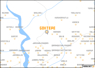
Göktepe (Şanlıurfa, Turkey)Göktepe is a town in the Şanlıurfa region of Turkey. An overview map of the region around Göktepe is displayed below.
regional and 3d topo map of Göktepe, Turkey ::
Göktepe airports ::
The nearest airport is GZT - Gaziantep Oguzeli, located 57.1 km west of Göktepe.
Other airports nearby include ALP - Aleppo Intl (112.9 km south west), MLX - Malatya Erhac (170.4 km north), EZS - Elazig (215.9 km north east), Nearby towns ::
Kūr ‘Alī (1.5km east) //
Bilekli (1.9km north) //
Horʼhori (3.0km east) //
Jārīkh al Fawqānī (5.1km south west) //
Qirānah (5.8km south) //
Şalīb (4.8km south east) //
Shārikhlī al Fawqānī (6.3km south west) //
Jārīkhl Taḩtānī (6.3km south west) //
Mishkū (7.4km south) //
Būyān (6.2km east) //
Qarah Qūyū al Fawqānī (7.1km south east) //
Kurukorkutlu (7.1km north east) //
Arslanlı (8.0km north) //
Jibnah (8.0km south) //
Qarah Qūyū at Taḩtānī (8.6km south east) //
Mağaralı (8.6km north west) //
Maqinţār (9.5km south east) //
Awkhān (9.5km south east) //
Bayāḑīyah (9.5km south west) //
[all distances 'as the bird flies' and approximate] 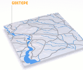 Places with similar names to Göktepe, Turkey ::
Disclaimer :: Information on this page comes without warranty of any kind |
||
|
Where is Göktepe? Elevation and coordinates ::
Latitude (lat): 36°54'0"N Longitude (lon): 38°7'0"E
Elevation (approx.): 472m (map arrows pan, magnifying glasses zoom) |
||
|
Visiting Göktepe? Hotel/Accommodation ::
Book a hotel in Göktepe Travel Guide ::
Buy a travel guide for Turkey rental cars ::
car rental offers GPS waypoint ::
download a GPX waypoint (PoI) of Göktepe for your GPS receiver
|
||