|
search place name
|
||
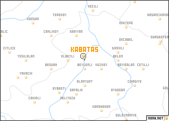
Kabataş (Ordu, Turkey)Kabataş is a town in the Ordu region of Turkey. An overview map of the region around Kabataş is displayed below.
regional and 3d topo map of Kabataş, Turkey ::
Kabataş airports ::
The nearest airport is VAS - Sivas, located 113.9 km south west of Kabataş.
Other airports nearby include MZH - Merzifon (163.0 km west), ASR - Kayseri Erkilet (276.3 km south west), Nearby towns ::
Beylerli (1.9km south) //
Elbeyli (2.8km west) //
Kuzköy (3.4km south east) //
Alanyurt (5.6km south) //
Sarıyar (5.7km north) //
Belen (5.6km east) //
Safalık (7.5km south) //
Direkli (5.9km east) //
Beşdam (5.9km west) //
Aybastı (8.2km south west) //
Çamlıköy (7.9km north west) //
Aydoğan (9.3km south east) //
[all distances 'as the bird flies' and approximate] 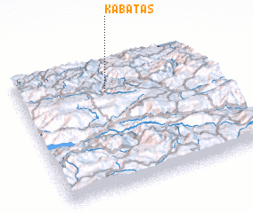 Places with similar names to Kabataş, Turkey ::
Disclaimer :: Information on this page comes without warranty of any kind |
||
|
Where is Kabataş? Elevation and coordinates ::
Latitude (lat): 40°45'0"N Longitude (lon): 37°27'0"E
Elevation (approx.): 449m (map arrows pan, magnifying glasses zoom) |
||
|
Visiting Kabataş? Hotel/Accommodation ::
Book a hotel in Kabataş Travel Guide ::
Buy a travel guide for Turkey rental cars ::
car rental offers GPS waypoint ::
download a GPX waypoint (PoI) of Kabataş for your GPS receiver
|
||