|
search place name
|
||
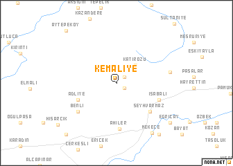
Kemaliye (Sakarya, Turkey)Kemaliye is a town in the Sakarya region of Turkey. An overview map of the region around Kemaliye is displayed below.
regional and 3d topo map of Kemaliye, Turkey ::
Kemaliye airports ::
The nearest airport is ESK - Eskisehir, located 95.7 km south east of Kemaliye.
Other airports nearby include IST - Istanbul Ataturk (112.5 km north west), AFY - Afyon (206.0 km south), Nearby towns ::
Akçakaya (1.2km south east) //
Hüseyinli (1.4km north east) //
Katırözü (3.7km north east) //
Adliye (5.4km south west) //
Şeyhvarmaz (6.0km south east) //
İsabalı (5.8km south east) //
Bacıköy (5.8km south east) //
Ahiler (7.4km south) //
Benli (6.5km south west) //
Bakacak (6.8km east) //
Mekece (9.0km south east) //
Ciciler (9.7km south east) //
Eğriçay (9.1km south east) //
Sarıyazı (10.3km south west) //
Aytepeköy (10.5km north west) //
[all distances 'as the bird flies' and approximate] 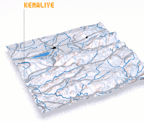 Places with similar names to Kemaliye, Turkey ::
Disclaimer :: Information on this page comes without warranty of any kind |
||
|
Where is Kemaliye? Elevation and coordinates ::
Latitude (lat): 40°31'26"N Longitude (lon): 30°0'22"E
Elevation (approx.): 745m (map arrows pan, magnifying glasses zoom) |
||
|
Visiting Kemaliye? Hotel/Accommodation ::
Book a hotel in Kemaliye Travel Guide ::
Buy a travel guide for Turkey rental cars ::
car rental offers GPS waypoint ::
download a GPX waypoint (PoI) of Kemaliye for your GPS receiver
|
||