|
search place name
|
||
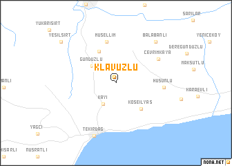
Klavuzlu (Tekirdağ, Turkey)Klavuzlu is a town in the Tekirdağ region of Turkey. An overview map of the region around Klavuzlu is displayed below.
regional and 3d topo map of Klavuzlu, Turkey ::
Klavuzlu airports ::
The nearest airport is BDM - Bandirma, located 89.8 km south east of Klavuzlu.
Other airports nearby include IST - Istanbul Ataturk (107.0 km east), AXD - Alexandroupolis Dimokritos (135.8 km west), BZI - Balikesir (162.9 km south), BOJ - Bourgas Burgas (168.0 km north), Nearby towns ::
Kayı (3.8km south west) //
Gündüzlü (4.0km north west) //
Kepenekli (5.4km north) //
Köseilyas (5.2km south east) //
Müsellim (6.7km north) //
Hüsünlü (5.9km east) //
Çevrimkaya (6.5km north east) //
Tekirdağ (8.9km south) //
Balabanlı (8.2km north east) //
[all distances 'as the bird flies' and approximate] 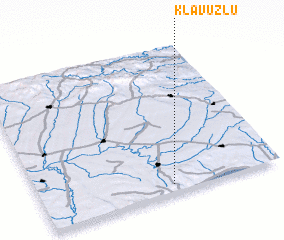 Places with similar names to Klavuzlu, Turkey ::
// Kılavuzlu (TR)
// Kalāgh Zeylī (IR)
Disclaimer :: Information on this page comes without warranty of any kind |
||
|
Where is Klavuzlu? Elevation and coordinates ::
Latitude (lat): 41°3'25"N Longitude (lon): 27°32'49"E
Elevation (approx.): 64m (map arrows pan, magnifying glasses zoom) |
||
|
Visiting Klavuzlu? Hotel/Accommodation ::
Book a hotel in Klavuzlu Travel Guide ::
Buy a travel guide for Turkey rental cars ::
car rental offers GPS waypoint ::
download a GPX waypoint (PoI) of Klavuzlu for your GPS receiver
|
||