|
search place name
|
||
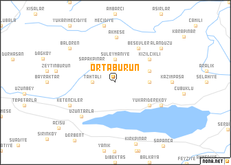
Ortaburun (Kocaeli, Turkey)Ortaburun is a town in the Kocaeli region of Turkey. An overview map of the region around Ortaburun is displayed below.
regional and 3d topo map of Ortaburun, Turkey ::
Ortaburun airports ::
The nearest airport is ESK - Eskisehir, located 115.6 km south of Ortaburun.
Other airports nearby include IST - Istanbul Ataturk (118.7 km west), Nearby towns ::
Tahtalı (2.8km west) //
Süleymaniye (3.7km north) //
Sapakpınar (4.2km north west) //
Dağyoncalı (4.2km east) //
Mahmudiye (4.6km north east) //
Beşevler (6.2km north east) //
Yukarı Dereköy (5.6km south east) //
Kızılcıklı (5.6km north east) //
Akmeşe (7.3km north) //
Uzuntarla (7.0km south west) //
Ketenciler (6.7km south west) //
Aşağıdere (6.7km south east) //
Balören (7.9km north west) //
Alandüzü (7.9km north east) //
[all distances 'as the bird flies' and approximate] 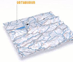
Disclaimer :: Information on this page comes without warranty of any kind |
||
|
Where is Ortaburun? Elevation and coordinates ::
Latitude (lat): 40°47'0"N Longitude (lon): 30°12'0"E
Elevation (approx.): 341m (map arrows pan, magnifying glasses zoom) |
||
|
Visiting Ortaburun? Hotel/Accommodation ::
Book a hotel in Ortaburun Travel Guide ::
Buy a travel guide for Turkey rental cars ::
car rental offers GPS waypoint ::
download a GPX waypoint (PoI) of Ortaburun for your GPS receiver
|
||