|
search place name
|
||
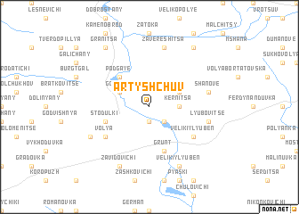
Artyshchuv (Ukraine)Artyshchuv is a town in Ukraine. An overview map of the region around Artyshchuv is displayed below.
regional and 3d topo map of Artyshchuv, Ukraine ::
Artyshchuv airports ::
The nearest airport is LWO - Lvov Lviv Intl, located 20.3 km east of Artyshchuv.
Other airports nearby include RZE - Rzeszow Jasionka (125.4 km west), Nearby towns ::
Cherlyany (1.9km south) //
Malkovitse (2.2km south east) //
Kernitsa (2.4km east) //
Gorodok (3.0km north west) //
Morgi (3.0km north east) //
Drozdovitse (4.4km north west) //
Podgaye (4.4km north west) //
Stodulki (4.0km south west) //
Grunt (5.7km south) //
Velikiy Lyubenʼ (5.2km south east) //
Volya (5.2km south west) //
Zavereshitsa (7.5km north) //
Shanove (5.1km east) //
Lyubovitse (5.1km east) //
Ugry (6.1km south west) //
Zavidovichi (7.8km south) //
Kosovets (7.8km south) //
Velikiy Lyubenʼ (7.8km south) //
Granitsa (8.2km north west) //
Povitnoye (8.2km north east) //
[all distances 'as the bird flies' and approximate]  Places with similar names to Artyshchuv, Ukraine ::
// Artishchevo (RU)
Disclaimer :: Information on this page comes without warranty of any kind |
||
|
Where is Artyshchuv? Elevation and coordinates ::
Latitude (lat): 49°46'0"N Longitude (lon): 23°41'0"E
Elevation (approx.): 271m (map arrows pan, magnifying glasses zoom) |
||
|
Visiting Artyshchuv? Hotel/Accommodation ::
Book a hotel in Artyshchuv Travel Guide ::
Buy a travel guide for Ukraine rental cars ::
car rental offers GPS waypoint ::
download a GPX waypoint (PoI) of Artyshchuv for your GPS receiver
|
||