|
search place name
|
||
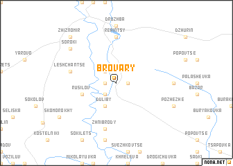
Brovary (Ukraine)Brovary is a town in Ukraine. An overview map of the region around Brovary is displayed below.
regional and 3d topo map of Brovary, Ukraine ::
Brovary airports ::
The nearest airport is LWO - Lvov Lviv Intl, located 143.6 km north west of Brovary.
Other airports nearby include SCV - Suceava Stefan Cel Mare (157.2 km south east), BAY - Baia Mare Tautii Magheraus (206.7 km south west), Nearby towns ::
Pomortsy (1.2km west) //
Pshedmesʼtse (1.2km east) //
Maly Zaleshchiki (2.2km north west) //
Yablonovka (2.2km south west) //
Duliby (3.9km south) //
Rusilov (4.1km south west) //
Repintsy (7.4km north) //
Leshchanʼtse (5.2km west) //
Zhnibrody (7.5km south) //
Soroki (7.4km north west) //
Zhiznomir (8.9km north west) //
[all distances 'as the bird flies' and approximate]  Places with similar names to Brovary, Ukraine ::
// Brefaro (IT)
// Brūveri (LV)
// Brūveri (LV)
// Brovar (UA)
// Brovary (UA)
// Bār Āvār (IR)
// Bear River (US)
// Boy River (US)
// Bāraghar (BD)
// Barāgharia (BD)
Disclaimer :: Information on this page comes without warranty of any kind |
||
|
Where is Brovary? Elevation and coordinates ::
Latitude (lat): 48°58'0"N Longitude (lon): 25°27'0"E
Elevation (approx.): 306m (map arrows pan, magnifying glasses zoom) |
||
|
Visiting Brovary? Hotel/Accommodation ::
Book a hotel in Brovary Travel Guide ::
Buy a travel guide for Ukraine rental cars ::
car rental offers GPS waypoint ::
download a GPX waypoint (PoI) of Brovary for your GPS receiver
|
||