|
search place name
|
||
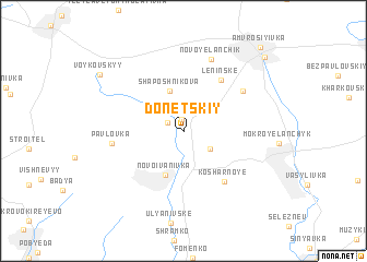
Donetskiy (Donetsʼka Oblastʼ, Ukraine)Donetskiy is a town in the Donetsʼka Oblastʼ region of Ukraine. An overview map of the region around Donetskiy is displayed below.
regional and 3d topo map of Donetskiy, Ukraine ::
Donetskiy airports ::
The nearest airport is DOK - Donetsk Intl, located 63.9 km north west of Donetskiy.
Other airports nearby include ROV - Rostov Na Donu (117.7 km south east), Nearby towns ::
Svistuny (1.2km north) //
Olʼginskiy (1.4km north west) //
Zadorozhnyy (2.5km south east) //
Shaposhnikova (4.2km north) //
Novoivanivka (4.6km south) //
Leninsʼke (5.8km north east) //
Kosharnoye (5.9km south east) //
Kiselëvka (5.8km north east) //
Pavlovka (5.1km west) //
Novoyelanchik (7.6km north) //
Voykovs'kyy (8.2km north west) //
Kaluzhka (9.4km north east) //
Amvrosiyivka (10.0km north east) //
[all distances 'as the bird flies' and approximate]  Places with similar names to Donetskiy, Ukraine ::
// Tandawzeik (MM)
// Teniatyska (PL)
// Donetskiy (UA)
// Donetskiy (UA)
// Donetsk (RU)
// Donetskiy (RU)
// Donetskiy (RU)
// Dandūskī (IR)
// Donetsk (KZ)
// Donetskoe (KZ)
Disclaimer :: Information on this page comes without warranty of any kind |
||
|
Where is Donetskiy? Elevation and coordinates ::
Latitude (lat): 47°42'56"N Longitude (lon): 38°24'32"E
Elevation (approx.): 99m (map arrows pan, magnifying glasses zoom) |
||
|
Visiting Donetskiy? Hotel/Accommodation ::
Book a hotel in Donetskiy Travel Guide ::
Buy a travel guide for Ukraine rental cars ::
car rental offers GPS waypoint ::
download a GPX waypoint (PoI) of Donetskiy for your GPS receiver
|
||