|
search place name
|
||
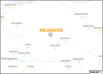
Polushkino (Luhansʼka Oblastʼ, Ukraine)Polushkino is a town in the Luhansʼka Oblastʼ region of Ukraine. An overview map of the region around Polushkino is displayed below.
regional and 3d topo map of Polushkino, Ukraine ::
Polushkino airports ::
The nearest airport is DOK - Donetsk Intl, located 207.0 km south of Polushkino.
Other airports nearby include VOZ - Voronezh Chertovitskoye (225.2 km north), Nearby towns ::
 Places with similar names to Polushkino, Ukraine ::
// Pleshkany (UA)
// Pelchuquin (CL)
// Ploshkin (KZ)
// Pahlūshekan (IR)
// Pleshkino (RU)
// Polushkino (RU)
// Plashkino (RU)
// Plashkino (RU)
// Pleshkino (RU)
// Plishkino (RU)
Disclaimer :: Information on this page comes without warranty of any kind |
||
|
Where is Polushkino? Elevation and coordinates ::
Latitude (lat): 49°55'10"N Longitude (lon): 38°6'14"E
Elevation (approx.): 172m (map arrows pan, magnifying glasses zoom) |
||
|
Visiting Polushkino? Hotel/Accommodation ::
Book a hotel in Polushkino Travel Guide ::
Buy a travel guide for Ukraine rental cars ::
car rental offers GPS waypoint ::
download a GPX waypoint (PoI) of Polushkino for your GPS receiver
|
||