|
search place name
|
||
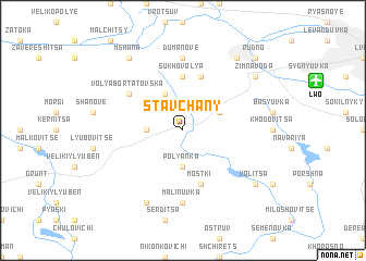
Stavchany (Ukraine)Stavchany is a town in Ukraine. An overview map of the region around Stavchany is displayed below.
regional and 3d topo map of Stavchany, Ukraine ::
Stavchany airports ::
The nearest airport is LWO - Lvov Lviv Intl, located 10.2 km north east of Stavchany.
Other airports nearby include RZE - Rzeszow Jasionka (135.7 km west), Nearby towns ::
Ferdynanduvka (2.4km west) //
Polyanka (3.7km south) //
Bartatov (3.9km north) //
Obroshino (3.0km north east) //
Sukhovolya (5.6km north) //
Konopnitsa (5.7km north) //
Mostki (5.7km south) //
Volya Bortatovska (5.2km north west) //
Dumanove (7.4km north) //
Malinuvka (7.4km south) //
Koloniya Dembyanka (7.8km south) //
Osichina (8.2km north east) //
Mshana (8.2km north west) //
Zimna Voda (7.3km north east) //
Vodyane (7.3km north east) //
Lesnevichi (7.3km south east) //
Volitsa (7.3km south east) //
Rudno (8.8km north east) //
[all distances 'as the bird flies' and approximate] 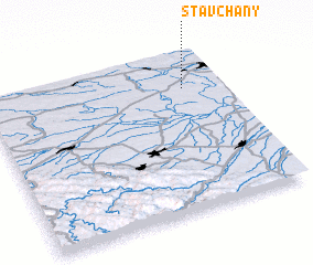
Disclaimer :: Information on this page comes without warranty of any kind |
||
|
Where is Stavchany? Elevation and coordinates ::
Latitude (lat): 49°46'0"N Longitude (lon): 23°50'0"E
Elevation (approx.): 279m (map arrows pan, magnifying glasses zoom) |
||
|
Visiting Stavchany? Hotel/Accommodation ::
Book a hotel in Stavchany Travel Guide ::
Buy a travel guide for Ukraine rental cars ::
car rental offers GPS waypoint ::
download a GPX waypoint (PoI) of Stavchany for your GPS receiver
|
||