|
search place name
|
||
Tigengagen (Ukraine)Tigengagen is a town in Ukraine. An overview map of the region around Tigengagen is displayed below.
regional and 3d topo map of Tigengagen, Ukraine ::

Tigengagen airports ::
The nearest airport is DNK - Dnepropetrovsk Dnipropetrovsk Intl, located 137.2 km north of Tigengagen.
Nearby towns ::
Dolina (2.2km south west) //
Alʼt-Nassau (3.9km north) //
Molochansʼk (4.6km north) //
Vaynau (3.8km west) //
Prishib (5.6km north) //
Schastlivoye (6.1km south east) //
Durlakh (5.4km west) //
Golubovka (5.4km east) //
Neyborg (5.4km east) //
Rot-Front (6.7km north east) //
Lindenau (8.3km south west) //
Lenino Vtoroye (9.0km north east) //
[all distances 'as the bird flies' and approximate] 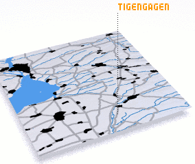 Places with similar names to Tigengagen, Ukraine :: Disclaimer :: Information on this page comes without warranty of any kind |
||
|
Where is Tigengagen? Elevation and coordinates ::
Latitude (lat): 47°10'0"N Longitude (lon): 35°35'0"E
Elevation (approx.): 30m (map arrows pan, magnifying glasses zoom) |
||
|
Visiting Tigengagen? Hotel/Accommodation ::
Book a hotel in Tigengagen Travel Guide ::
Buy a travel guide for Ukraine rental cars ::
car rental offers GPS waypoint ::
download a GPX waypoint (PoI) of Tigengagen for your GPS receiver
|
||