|
search place name
|
||
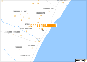
Dar Ben Slimane (Nabeul, Tunisia)Dar Ben Slimane is a town in the Nabeul region of Tunisia. An overview map of the region around Dar Ben Slimane is displayed below.
regional and 3d topo map of Dar Ben Slimane, Tunisia ::
Dar Ben Slimane airports ::
The nearest airport is TUN - Tunis Carthage, located 63.5 km north west of Dar Ben Slimane.
Other airports nearby include MIR - Monastir Habib Bourguiba Intl (96.0 km south), PNL - Pantelleria (100.0 km east), LMP - Lampedusa (200.1 km south east), TPS - Trapani Birgi (202.6 km north east), Nearby towns ::
Diar el Hajjej (1.7km north west) //
Hennchir Bir Bou Zouita (4.2km north west) //
Korba (4.6km south) //
Tobag (5.6km north) //
Beni Aïchoun (5.5km south west) //
Krouibia (5.4km west) //
Kourchine (6.7km north) //
Tir el Mergueb (5.9km west) //
Dar Taleb Mohammed (7.4km north west) //
Tazarka (8.4km south west) //
Tafelloune (8.8km north) //
Dar Bou Agine (9.1km north west) //
Bou el Azhar (9.5km north west) //
[all distances 'as the bird flies' and approximate] 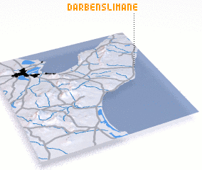 Places with similar names to Dar Ben Slimane, Tunisia :: Disclaimer :: Information on this page comes without warranty of any kind |
||
|
Where is Dar Ben Slimane? Elevation and coordinates ::
Latitude (lat): 36°37'4"N Longitude (lon): 10°52'36"E
Elevation (approx.): 12m (map arrows pan, magnifying glasses zoom) |
||
|
Visiting Dar Ben Slimane? Hotel/Accommodation ::
Book a hotel in Dar Ben Slimane Travel Guide ::
Buy a travel guide for Tunisia rental cars ::
car rental offers GPS waypoint ::
download a GPX waypoint (PoI) of Dar Ben Slimane for your GPS receiver
|
||