|
search place name
|
||
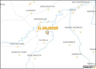
El Haj Amor (Jendouba, Tunisia)El Haj Amor is a town in the Jendouba region of Tunisia. An overview map of the region around El Haj Amor is displayed below.
regional and 3d topo map of El Haj Amor, Tunisia ::
El Haj Amor airports ::
The nearest airport is AAE - Annaba, located 97.4 km north west of El Haj Amor.
Other airports nearby include TUN - Tunis Carthage (132.3 km east), TEE - Tebessa Cheikh Larbi Tebessi (133.1 km south west), MIR - Monastir Habib Bourguiba Intl (192.3 km south east), SFA - Sfax Thyna (259.7 km south east), Nearby towns ::
El Khelij (3.5km south) //
Jendouba (3.7km west) //
Mohammed Ben Bel Kassem (4.2km north west) //
Mahmoud Ben el Haj (4.4km north west) //
Ahmed Ben Ali (4.9km north) //
En Merhamcha (5.4km north west) //
Sidi es Sabbih (7.9km south east) //
El Hammam (9.7km north west) //
[all distances 'as the bird flies' and approximate] 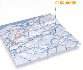 Places with similar names to El Haj Amor, Tunisia ::
// El Haj Amar (MA)
// El Haj Omar (MA)
Disclaimer :: Information on this page comes without warranty of any kind |
||
|
Where is El Haj Amor? Elevation and coordinates ::
Latitude (lat): 36°29'20"N Longitude (lon): 8°49'3"E
Elevation (approx.): 143m (map arrows pan, magnifying glasses zoom) |
||
|
Visiting El Haj Amor? Hotel/Accommodation ::
Book a hotel in El Haj Amor Travel Guide ::
Buy a travel guide for Tunisia rental cars ::
car rental offers GPS waypoint ::
download a GPX waypoint (PoI) of El Haj Amor for your GPS receiver
|
||