|
search place name
|
||
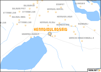
Henndi Oulad Saïd (Sousse, Tunisia)Henndi Oulad Saïd is a town in the Sousse region of Tunisia. An overview map of the region around Henndi Oulad Saïd is displayed below.
regional and 3d topo map of Henndi Oulad Saïd, Tunisia ::
Henndi Oulad Saïd airports ::
The nearest airport is MIR - Monastir Habib Bourguiba Intl, located 40.1 km south east of Henndi Oulad Saïd.
Other airports nearby include TUN - Tunis Carthage (103.4 km north), SFA - Sfax Thyna (137.3 km south), PNL - Pantelleria (174.8 km north east), GAF - Gafsa (217.9 km south west), Nearby towns ::
Henndi ech Chiab (0.5km east) //
Dar el Haj Amara (1.3km east) //
Henndi el Alouj (4.1km north) //
Henndi Knana (4.9km north east) //
Sidi et Taïari (5.5km north east) //
Mashtá ash Shuwayshah (5.6km north east) //
Douar Oulad Aoun (5.9km west) //
Henndi Salmoun (7.5km north east) //
Henndi es Setta (7.3km north east) //
Sidi Khalifa el Ferjani (8.4km north west) //
Henndi el Haj Brahim (7.2km east) //
Henndi el Menzel (9.0km north) //
Oulad el Abed (9.2km north west) //
Et Trabelsia (10.1km north west) //
[all distances 'as the bird flies' and approximate] 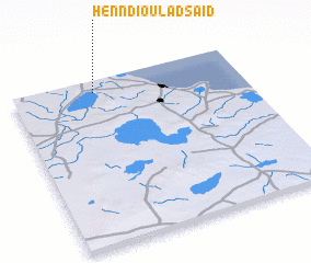 Places with similar names to Henndi Oulad Saïd, Tunisia :: Disclaimer :: Information on this page comes without warranty of any kind |
||
|
Where is Henndi Oulad Saïd? Elevation and coordinates ::
Latitude (lat): 35°55'33"N Longitude (lon): 10°21'42"E
Elevation (approx.): 18m (map arrows pan, magnifying glasses zoom) |
||
|
Visiting Henndi Oulad Saïd? Hotel/Accommodation ::
Book a hotel in Henndi Oulad Saïd Travel Guide ::
Buy a travel guide for Tunisia rental cars ::
car rental offers GPS waypoint ::
download a GPX waypoint (PoI) of Henndi Oulad Saïd for your GPS receiver
|
||