|
search place name
|
||
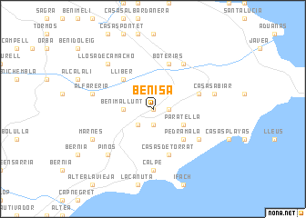
Benisa (Comunidad Valenciana, Spain)Benisa is a town in the Comunidad Valenciana region of Spain. An overview map of the region around Benisa is displayed below.
regional and 3d topo map of Benisa, Spain ::
Benisa airports ::
The nearest airport is ALC - Alicante, located 71.7 km south west of Benisa.
Other airports nearby include VLC - Valencia (97.3 km north west), IBZ - Ibiza (116.2 km east), MJV - Murcia San Javier (128.9 km south west), Nearby towns ::
Senija (0.0km north) //
Serrallonga (1.9km south) //
Berdica (1.4km east) //
Canor (1.4km east) //
San Antonio (2.4km south west) //
Benimallunt (2.9km west) //
Paratella (3.4km south east) //
Lliber (4.7km north west) //
Pedramala (4.7km south east) //
Teulada (4.7km north east) //
Casas de Torrat (5.7km south) //
Boterías (5.7km north) //
Gata de Gorgos (6.3km north east) //
Fanadix (5.7km south east) //
Calpe (7.4km south) //
Alfarería (6.1km west) //
Casas Abiar (6.1km east) //
Jalón (6.1km west) //
Piños (7.1km south west) //
Llosa de Camacho (7.1km north west) //
Marnes (6.9km south west) //
[all distances 'as the bird flies' and approximate]  Places with similar names to Benisa, Spain ::
Disclaimer :: Information on this page comes without warranty of any kind |
||
|
Where is Benisa? Elevation and coordinates ::
Latitude (lat): 38°43'0"N Longitude (lon): 0°3'0"W
Elevation (approx.): 266m (map arrows pan, magnifying glasses zoom) |
||
|
Visiting Benisa? Hotel/Accommodation ::
Book a hotel in Benisa Travel Guide ::
Buy a travel guide for Spain rental cars ::
car rental offers GPS waypoint ::
download a GPX waypoint (PoI) of Benisa for your GPS receiver
|
||