|
search place name
|
||
Bentarique (Andalucía, Spain)Bentarique is a town in the Andalucía region of Spain. An overview map of the region around Bentarique is displayed below.
regional and 3d topo map of Bentarique, Spain ::

Bentarique airports ::
The nearest airport is LEI - Almeria, located 26.9 km south east of Bentarique.
Other airports nearby include GRX - Granada Armilla (92.1 km west), GRX - Granada (105.7 km west), AGP - Malaga (171.4 km west), MJV - Murcia San Javier (182.4 km north east), Nearby towns ::
Illar (1.5km west) //
Huécija (1.9km south) //
Terque (1.5km east) //
Alicún (2.4km south east) //
Instinción (3.0km west) //
Alhabia (3.0km east) //
Alsodux (3.5km north east) //
Santa Cruz (4.0km north) //
Albolodúy (5.6km north) //
Alhama de Almería (5.8km south east) //
Galáchar (5.9km east) //
La Fuente de Los Morales (6.2km west) //
Rágol (6.2km west) //
Los Imposibles (6.2km east) //
[all distances 'as the bird flies' and approximate] 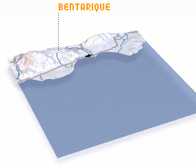 Places with similar names to Bentarique, Spain ::
// Bandurica (BA)
// Bontrug (ZA)
// Bondarka (RU)
// Bandargāh (IR)
// Bandargāh (IR)
// Bandargāh (IR)
// Bantirago (GH)
// Bint Ruqayyah (SD)
// Bandirak (SY)
// Ban Tariak (LA)
Disclaimer :: Information on this page comes without warranty of any kind |
||
|
Where is Bentarique? Elevation and coordinates ::
Latitude (lat): 36°59'0"N Longitude (lon): 2°37'0"W
Elevation (approx.): 322m (map arrows pan, magnifying glasses zoom) |
||
|
Visiting Bentarique? Hotel/Accommodation ::
Book a hotel in Bentarique Travel Guide ::
Buy a travel guide for Spain rental cars ::
car rental offers GPS waypoint ::
download a GPX waypoint (PoI) of Bentarique for your GPS receiver
|
||