|
search place name
|
||
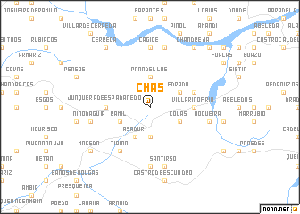
Chas (Galicia, Spain)Chas is a town in the Galicia region of Spain. An overview map of the region around Chas is displayed below.
regional and 3d topo map of Chas, Spain ::
Chas airports ::
The nearest airport is VGO - Vigo, located 86.6 km west of Chas.
Other airports nearby include BGC - Braganca (88.6 km south east), SCQ - Santiago (93.8 km north west), VRL - Vila Real (116.3 km south), LCG - La Coruna A Coruna (127.3 km north west), Nearby towns ::
Paradellas (3.7km north) //
La Cuesta (3.7km south) //
Edrada (3.3km north east) //
Covas (3.3km south east) //
Asadur (4.0km south) //
Ramil (3.3km south west) //
Villarino Frío (4.1km east) //
Junquera de Espadañedo (4.1km west) //
Pradomao (4.5km north east) //
Tioira (6.2km south west) //
Cagide (7.4km north) //
Villardecás (7.4km south) //
Parada del Sil (7.5km north) //
Nogueira (5.8km east) //
Santirso (7.5km south) //
Niñodaguía (5.8km west) //
Chandreja (8.5km north east) //
Cerreda (8.5km north west) //
Maceda (7.8km south west) //
Sacardebois (9.2km north east) //
[all distances 'as the bird flies' and approximate] 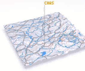 Places with similar names to Chas, Spain ::
Disclaimer :: Information on this page comes without warranty of any kind |
||
|
Where is Chas? Elevation and coordinates ::
Latitude (lat): 42°19'0"N Longitude (lon): 7°35'0"W
Elevation (approx.): 947m (map arrows pan, magnifying glasses zoom) |
||
|
Visiting Chas? Hotel/Accommodation ::
Book a hotel in Chas Travel Guide ::
Buy a travel guide for Spain rental cars ::
car rental offers GPS waypoint ::
download a GPX waypoint (PoI) of Chas for your GPS receiver
|
||