|
search place name
|
||
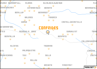
Confrides (Comunidad Valenciana, Spain)Confrides is a town in the Comunidad Valenciana region of Spain. An overview map of the region around Confrides is displayed below.
regional and 3d topo map of Confrides, Spain ::
Confrides airports ::
The nearest airport is ALC - Alicante, located 51.3 km south west of Confrides.
Other airports nearby include VLC - Valencia (91.4 km north), MJV - Murcia San Javier (111.6 km south west), IBZ - Ibiza (144.0 km east), Nearby towns ::
Abdet (2.4km north east) //
Facheca (5.6km north) //
Beniardá (4.3km east) //
Ares (4.3km west) //
Tagarina (5.6km south) //
Benifató (4.7km south east) //
Famorca (5.7km north) //
Cuatretondeta (5.7km north west) //
Alcolecha (5.8km west) //
Benasau (5.8km west) //
Tollos (7.4km north) //
Benimantell (5.8km east) //
Benimasot (7.6km north) //
La Rapella (8.0km south) //
Balones (8.0km north west) //
Palanquetas (9.4km south west) //
[all distances 'as the bird flies' and approximate] 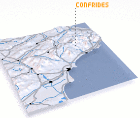 Places with similar names to Confrides, Spain :: Disclaimer :: Information on this page comes without warranty of any kind |
||
|
Where is Confrides? Elevation and coordinates ::
Latitude (lat): 38°41'0"N Longitude (lon): 0°16'0"W
Elevation (approx.): 754m (map arrows pan, magnifying glasses zoom) |
||
|
Visiting Confrides? Hotel/Accommodation ::
Book a hotel in Confrides Travel Guide ::
Buy a travel guide for Spain rental cars ::
car rental offers GPS waypoint ::
download a GPX waypoint (PoI) of Confrides for your GPS receiver
|
||