|
search place name
|
||
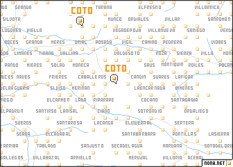
Coto (Asturias, Spain)Coto is a town in the Asturias region of Spain. An overview map of the region around Coto is displayed below.
regional and 3d topo map of Coto, Spain ::
Coto airports ::
The nearest airport is OVD - Aviles Asturias, located 40.3 km north west of Coto.
Other airports nearby include SDR - Santander (148.7 km east), BGC - Braganca (185.5 km south west), VLL - Valladolid (192.3 km south), Nearby towns ::
Raíz de Arriba (1.3km east) //
Tuilla (1.3km east) //
Rosellón (1.3km east) //
La Nava (1.3km west) //
Pando (2.3km south west) //
Carbayín (2.3km north east) //
Arenas (2.3km north east) //
Caballeros (2.7km west) //
Candín (2.7km east) //
Tiroco de Arriba (3.7km north) //
Leceñes (3.7km north) //
La Felguera (3.3km south west) //
Braña del Río (3.3km south east) //
Ceacal (3.3km south east) //
Molledo (3.3km north west) //
La Acebal (3.9km south) //
Riparape (3.9km south) //
Valdesoto (3.9km north) //
Tiroco de Abajo (3.9km north) //
Castiello (3.9km north) //
Turiellos (4.6km south west) //
Sama (4.6km south west) //
Lamuño (4.6km north east) //
La Vega (5.6km south) //
Negales (5.6km north) //
Santa Ana (5.6km south) //
Acebal (4.0km west) //
Comba (4.0km east) //
Barros (4.4km south west) //
[all distances 'as the bird flies' and approximate] 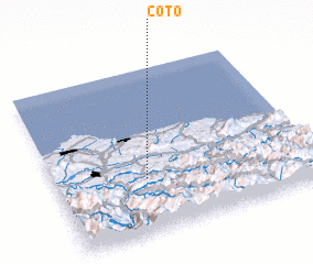 Places with similar names to Coto, Spain ::
Disclaimer :: Information on this page comes without warranty of any kind |
||
|
Where is Coto? Elevation and coordinates ::
Latitude (lat): 43°20'0"N Longitude (lon): 5°39'0"W
Elevation (approx.): 339m (map arrows pan, magnifying glasses zoom) |
||
|
Visiting Coto? Hotel/Accommodation ::
Book a hotel in Coto Travel Guide ::
Buy a travel guide for Spain rental cars ::
car rental offers GPS waypoint ::
download a GPX waypoint (PoI) of Coto for your GPS receiver
|
||