|
search place name
|
||
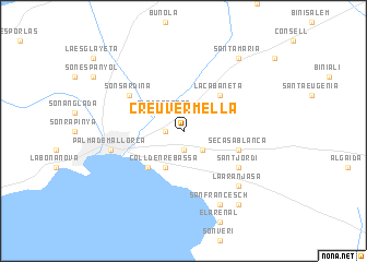
Creu Vermella (Islas Baleares, Spain)Creu Vermella is a town in the Islas Baleares region of Spain. An overview map of the region around Creu Vermella is displayed below.
regional and 3d topo map of Creu Vermella, Spain ::
Creu Vermella airports ::
The nearest airport is PMI - Palma De Mallorca (Son San Juan), located 4.0 km south east of Creu Vermella.
Other airports nearby include MAH - Menorca (132.5 km east), IBZ - Ibiza (140.3 km south west), BCN - Barcelona (197.9 km north), REU - Reus (217.9 km north west), Nearby towns ::
Son Ferriol (1.9km south) //
Pont dʼInca (1.4km west) //
El Vivero (2.3km south east) //
Pla de na Tesa (2.3km north west) //
Coll dʼen Rebassa (4.0km south) //
Indiotería (3.4km north west) //
Molinar de Levante (4.7km south west) //
La Cabaneta (4.7km north east) //
Se Casa Blanca (4.7km south east) //
Sant Jordi (5.7km south east) //
Son Sardina (5.7km north west) //
Palma de Mallorca (6.0km west) //
La Aranjasa (7.0km south east) //
San Francesch (7.9km south) //
Los Ángeles (8.6km south east) //
Santa María (8.6km north east) //
[all distances 'as the bird flies' and approximate] 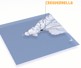 Places with similar names to Creu Vermella, Spain :: Disclaimer :: Information on this page comes without warranty of any kind |
||
|
Where is Creu Vermella? Elevation and coordinates ::
Latitude (lat): 39°35'0"N Longitude (lon): 2°43'0"E
Elevation (approx.): 27m (map arrows pan, magnifying glasses zoom) |
||
|
Visiting Creu Vermella? Hotel/Accommodation ::
Book a hotel in Creu Vermella Travel Guide ::
Buy a travel guide for Spain rental cars ::
car rental offers GPS waypoint ::
download a GPX waypoint (PoI) of Creu Vermella for your GPS receiver
|
||