|
search place name
|
||
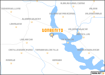
Don Benito (Castilla-La Mancha, Spain)Don Benito is a town in the Castilla-La Mancha region of Spain. An overview map of the region around Don Benito is displayed below.
regional and 3d topo map of Don Benito, Spain ::
Don Benito airports ::
The nearest airport is TOJ - Madrid Torrejon, located 132.9 km north west of Don Benito.
Other airports nearby include MAD - Madrid Barajas (140.5 km north west), VLC - Valencia (156.5 km east), ALC - Alicante (217.0 km south east), ZAZ - Zaragoza Ab (242.3 km north east), Nearby towns ::
Talayuelas (4.7km south east) //
Torrubia del Castillo (5.7km south) //
Villaverde y Pasaconsol (7.9km north) //
Olivares de Júcar (8.0km north west) //
[all distances 'as the bird flies' and approximate]  Places with similar names to Don Benito, Spain ::
// Don Benito (PH)
// Tanbindaw (MM)
// Don Benito (ES)
// Tanbouandi (BF)
// Dan Binta (NE)
// Danna Bāndi (PK)
// Tounboundi (ML)
// Tounboundi (ML)
// Tounbounto (ML)
// Donai Bānda (PK)
Disclaimer :: Information on this page comes without warranty of any kind |
||
|
Where is Don Benito? Elevation and coordinates ::
Latitude (lat): 39°42'0"N Longitude (lon): 2°17'0"W
Elevation (approx.): 825m (map arrows pan, magnifying glasses zoom) |
||
|
Visiting Don Benito? Hotel/Accommodation ::
Book a hotel in Don Benito Travel Guide ::
Buy a travel guide for Spain rental cars ::
car rental offers GPS waypoint ::
download a GPX waypoint (PoI) of Don Benito for your GPS receiver
|
||