|
search place name
|
||
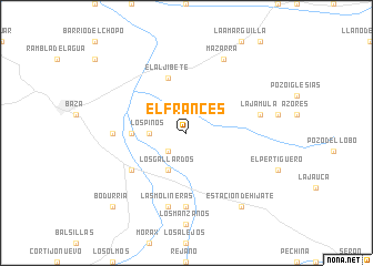
El Francés (Andalucía, Spain)El Francés is a town in the Andalucía region of Spain. An overview map of the region around El Francés is displayed below.
regional and 3d topo map of El Francés, Spain ::
El Francés airports ::
The nearest airport is LEI - Almeria, located 74.0 km south of El Francés.
Other airports nearby include GRX - Granada Armilla (93.5 km south west), GRX - Granada (103.2 km west), MJV - Murcia San Javier (167.2 km east), AGP - Malaga (185.1 km south west), Nearby towns ::
Los Mesas (2.4km south west) //
Los Pinos (2.9km west) //
Los Gallardos (4.0km south) //
Cuevas de las Yeseras (4.4km west) //
El Aljibete (5.8km north) //
Caniles (5.8km south west) //
Fábrica Azucarera (5.9km west) //
Balax (7.4km south) //
Las Molineras (7.6km south) //
La Jámula (6.2km east) //
Mazarra (8.0km north) //
Estación de Hijate (8.6km south east) //
Bodurria (9.5km south west) //
[all distances 'as the bird flies' and approximate]  Places with similar names to El Francés, Spain ::
// El Francés (CU)
// El Francés (CU)
// El Francés (CU)
// El Francés (CO)
// El Francés (MX)
// El Francés (MX)
// El Francés (VE)
// El Francés (DO)
Disclaimer :: Information on this page comes without warranty of any kind |
||
|
Where is El Francés? Elevation and coordinates ::
Latitude (lat): 37°28'0"N Longitude (lon): 2°40'0"W
Elevation (approx.): 909m (map arrows pan, magnifying glasses zoom) |
||
|
Visiting El Francés? Hotel/Accommodation ::
Book a hotel in El Francés Travel Guide ::
Buy a travel guide for Spain rental cars ::
car rental offers GPS waypoint ::
download a GPX waypoint (PoI) of El Francés for your GPS receiver
|
||