|
search place name
|
||
Ergoyena (País Vasco, Spain)Ergoyena is a town in the País Vasco region of Spain. An overview map of the region around Ergoyena is displayed below.
regional and 3d topo map of Ergoyena, Spain ::

Ergoyena airports ::
The nearest airport is VIT - Vitoria, located 46.5 km west of Ergoyena.
Other airports nearby include PNA - Pamplona (47.8 km south east), EAS - San Sebastian (53.0 km north east), BIO - Bilbao (71.0 km north west), BIQ - Biarritz-bayonne Anglet (76.4 km north east), Nearby towns ::
San Gregorio (2.3km north west) //
Aya (2.3km south east) //
Ataun (3.7km north) //
Arrondoa (3.9km north) //
Elbarrena (5.6km north) //
Aitzarte (5.6km north) //
Ursuarán (5.4km west) //
Lazcaumendi (7.4km north) //
Lazcano (7.5km north) //
Zaldivia (7.5km north) //
La Estación (7.5km south) //
Idiazábal (6.9km north west) //
Olaberría (7.9km north) //
Yurre (8.5km north west) //
[all distances 'as the bird flies' and approximate] 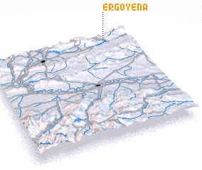
Disclaimer :: Information on this page comes without warranty of any kind |
||
|
Where is Ergoyena? Elevation and coordinates ::
Latitude (lat): 42°58'0"N Longitude (lon): 2°10'0"W
Elevation (approx.): 383m (map arrows pan, magnifying glasses zoom) |
||
|
Visiting Ergoyena? Hotel/Accommodation ::
Book a hotel in Ergoyena Travel Guide ::
Buy a travel guide for Spain rental cars ::
car rental offers GPS waypoint ::
download a GPX waypoint (PoI) of Ergoyena for your GPS receiver
|
||