|
search place name
|
||
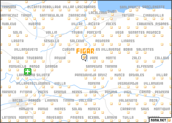
Figar (Asturias, Spain)Figar is a town in the Asturias region of Spain. An overview map of the region around Figar is displayed below.
regional and 3d topo map of Figar, Spain ::
Figar airports ::
The nearest airport is OVD - Aviles Asturias, located 28.6 km north west of Figar.
Other airports nearby include SDR - Santander (153.6 km east), BGC - Braganca (194.6 km south west), VLL - Valladolid (206.3 km south), Nearby towns ::
San Tirso (1.3km east) //
Varé (1.3km east) //
Huergo (1.9km south) //
Aguda (2.3km north west) //
Ruedes (2.3km north east) //
San Pedro (2.3km south east) //
Fontaciera (3.7km north) //
Peñaferruz (2.7km west) //
Barganiza (2.7km west) //
Pañeda Vieja (3.7km south) //
Pañeda Nueva (3.7km south) //
Calabaza (2.7km east) //
Salcedo (3.9km north) //
Piñera (3.9km north) //
Arroyo (3.9km north) //
Cuadra (3.3km north west) //
Carbaínos (3.3km north west) //
Anés (3.9km south) //
Coto (3.9km south) //
Beranes (4.6km north west) //
Garvelles (4.6km north west) //
Caldones (4.6km north west) //
Robledo (4.6km north west) //
Pedrera (4.6km north east) //
Llantones (4.6km north east) //
Leorio (4.6km north east) //
Orviz (4.6km south east) //
Celles (4.6km south east) //
Caravedo (5.6km north) //
[all distances 'as the bird flies' and approximate]  Places with similar names to Figar, Spain ::
Disclaimer :: Information on this page comes without warranty of any kind |
||
|
Where is Figar? Elevation and coordinates ::
Latitude (lat): 43°27'0"N Longitude (lon): 5°43'0"W
Elevation (approx.): 81m (map arrows pan, magnifying glasses zoom) |
||
|
Visiting Figar? Hotel/Accommodation ::
Book a hotel in Figar Travel Guide ::
Buy a travel guide for Spain rental cars ::
car rental offers GPS waypoint ::
download a GPX waypoint (PoI) of Figar for your GPS receiver
|
||