|
search place name
|
||
Hontamió (Asturias, Spain)Hontamió is a town in the Asturias region of Spain. An overview map of the region around Hontamió is displayed below.
regional and 3d topo map of Hontamió, Spain ::

Hontamió airports ::
The nearest airport is SDR - Santander, located 63.1 km east of Hontamió.
Other airports nearby include OVD - Aviles Asturias (120.6 km west), BIO - Bilbao (135.7 km east), VIT - Vitoria (158.8 km east), VLL - Valladolid (180.3 km south), Nearby towns ::
Suarias (0.0km north) //
Cimiano (1.3km east) //
Panes (1.9km north) //
Siejo (1.9km north) //
Alevia (2.3km north west) //
Abándames (2.3km north west) //
Tobes (2.7km west) //
Cerébanes (2.7km west) //
Robriguero (2.7km west) //
El Mazo (3.3km north east) //
Narganes (3.3km north east) //
Cavandi (3.3km north west) //
Merodio (4.0km east) //
Para (4.0km west) //
Bojes (5.6km north) //
Buelles (4.4km north east) //
Noriega (5.7km north) //
Boquerizo (5.7km north) //
Andinas (5.5km north east) //
Villanueva (6.2km north east) //
Cuñaba (5.5km south west) //
Las Conchas (7.4km north) //
Linares (7.4km south) //
Navedo (7.4km south) //
Bores (5.4km west) //
La Franca (7.5km north) //
Tresgrandas (7.5km north) //
Roza (7.5km south) //
Llonín (5.7km west) //
[all distances 'as the bird flies' and approximate] 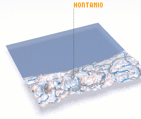 Places with similar names to Hontamió, Spain ::
Disclaimer :: Information on this page comes without warranty of any kind |
||
|
Where is Hontamió? Elevation and coordinates ::
Latitude (lat): 43°19'0"N Longitude (lon): 4°35'0"W
Elevation (approx.): 125m (map arrows pan, magnifying glasses zoom) |
||
|
Visiting Hontamió? Hotel/Accommodation ::
Book a hotel in Hontamió Travel Guide ::
Buy a travel guide for Spain rental cars ::
car rental offers GPS waypoint ::
download a GPX waypoint (PoI) of Hontamió for your GPS receiver
|
||