|
search place name
|
||
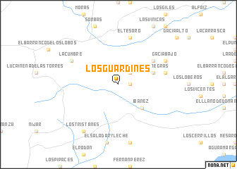
Los Guardines (Andalucía, Spain)Los Guardines is a town in the Andalucía region of Spain. An overview map of the region around Los Guardines is displayed below.
regional and 3d topo map of Los Guardines, Spain ::
Los Guardines airports ::
The nearest airport is LEI - Almeria, located 33.1 km south west of Los Guardines.
Other airports nearby include GRX - Granada Armilla (138.5 km west), MJV - Murcia San Javier (139.4 km north east), GRX - Granada (151.6 km west), ALC - Alicante (193.2 km north east), Nearby towns ::
El Puntal (1.5km east) //
Polopos (1.5km east) //
Mizala (2.4km north east) //
Ibáñez (4.7km south east) //
Peñas Negras (4.8km north east) //
El Campico (5.8km north east) //
Gafarillos (6.2km east) //
El Río de Aguas (7.6km north) //
El Tesoro (7.6km north) //
Gacia Bajo (7.0km north east) //
La Cumbre (7.0km north west) //
Los Tristanes (8.6km south west) //
[all distances 'as the bird flies' and approximate]  Places with similar names to Los Guardines, Spain ::
// Las Cardonas (ES)
// Las Gardenias (CO)
// Los Cardones (CO)
// Las Cardenas (MX)
// Los Cárdenas (MX)
// Luis Cárdenas (MX)
// Las Cortinas (HN)
// Los Cardones (VE)
// Los Cardones (VE)
// Los Cardones (VE)
Disclaimer :: Information on this page comes without warranty of any kind |
||
|
Where is Los Guardines? Elevation and coordinates ::
Latitude (lat): 37°2'0"N Longitude (lon): 2°5'0"W
Elevation (approx.): 415m (map arrows pan, magnifying glasses zoom) |
||
|
Visiting Los Guardines? Hotel/Accommodation ::
Book a hotel in Los Guardines Travel Guide ::
Buy a travel guide for Spain rental cars ::
car rental offers GPS waypoint ::
download a GPX waypoint (PoI) of Los Guardines for your GPS receiver
|
||