|
search place name
|
||
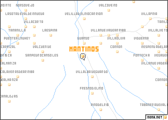
Mantinos (Castilla y León, Spain)Mantinos is a town in the Castilla y León region of Spain. An overview map of the region around Mantinos is displayed below.
regional and 3d topo map of Mantinos, Spain ::
Mantinos airports ::
The nearest airport is SDR - Santander, located 111.6 km north east of Mantinos.
Other airports nearby include VLL - Valladolid (116.0 km south), OVD - Aviles Asturias (133.1 km north west), BIO - Bilbao (168.2 km east), BGC - Braganca (183.6 km south west), Nearby towns ::
Guardo (3.7km north) //
Villalba de Guardo (3.9km south) //
Intorcisa (4.6km north east) //
Muñeca (6.2km north east) //
Cornón (5.7km east) //
Fresno del Río (7.5km south) //
Villanueva de Arriba (6.9km north east) //
Villaoliva (6.6km north east) //
Las Heras (7.8km north east) //
La Espina (7.8km north west) //
[all distances 'as the bird flies' and approximate]  Places with similar names to Mantinos, Spain ::
// Mantanas (PH)
// Montanes (IT)
// Montanesi (IT)
// Montañas (MX)
// Montañés (MX)
// Montenuasi (PE)
// M. Antunes (MZ)
// Mandanici (IT)
// Minitonas (CA)
// Montans (FR)
Disclaimer :: Information on this page comes without warranty of any kind |
||
|
Where is Mantinos? Elevation and coordinates ::
Latitude (lat): 42°45'0"N Longitude (lon): 4°50'0"W
Elevation (approx.): 1101m (map arrows pan, magnifying glasses zoom) |
||
|
Visiting Mantinos? Hotel/Accommodation ::
Book a hotel in Mantinos Travel Guide ::
Buy a travel guide for Spain rental cars ::
car rental offers GPS waypoint ::
download a GPX waypoint (PoI) of Mantinos for your GPS receiver
|
||